|
Rocko1 Posts: 615
12/11/2019
|
Had a couple days off and decided to finish my west approach(actually south west) of Granite. I parked a little bit off S2 and took the old mining road up-this time following it all the way to the mines. It had rained the day before. Everything smelled great. Was about 48f when I started, and a bit cooler than that at the top.
Lots of left over metal/trash from the operation.

From what I can tell looks like a 40-60’s era oil can?


This is at the below the mines looking south.

The first most open mine. I was not peaking in for a look.

Second one had a large boulder blocking the entrance. Not sure if it was intentional or not.

On top of the first ridge looking to the east at Whale in the background.

About 3 miles in you hit a pretty dense cactus garden.

Video of how that section looks.- https://youtu.be/s7m0T4cfkVQ
Looking up the ridge. Only obstacle is the dike.


Past that it’s a pretty easy navigation to the peak. A bit of scrambling to get on top of the peak.

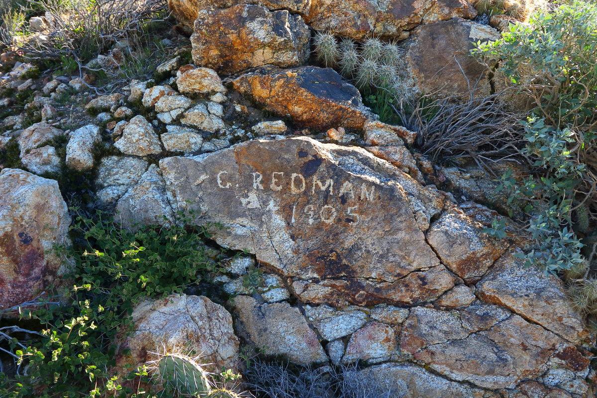
Three makers.


Sadly the register that was in the red coffee cans was missing. It was there when I was here in the beginning of the year. I looked around thinking it fell off but no luck.
Good view of Toro with snow.

360 View
https://youtu.be/ABSpjUu5X78
Found a good spot to take a break and try out the new chair. REI Flexlite Air. 16oz. Pretty comfortable!

Down the ridge I go.

Healthy pine tree . Love to see these trees in AB.

More ‘gear’ near the mine. Vintage tall boy?

Sleeping accommodations.

Followed the mine road back to Rodriguez Canyon Rd and then back to the car. It’s pretty good hike.
11.5 miles, 3,400ft gain.

I like this route better than the east side as there is less scrambling. I would be interested to know what they were mining and when the operation was active.
edited by Rocko1 on 12/11/2019
edited by Rocko1 on 12/13/2019
|
|
|
+1
link
|
|
Buford Posts: 467
12/11/2019
|
That's looks like a fun way to do Grapevine. Thanks for putting up the pictures of the scenery along the way. I can't believe you packed a chair all the way up.
--
Links to my photos: ABDSP photos, Bighorn sheep photos, ABDSP time lapse video, Wildlife photos (mainly birds)
|
|
|
+1
link
|
|
Rocko1 Posts: 615
12/12/2019
|
Buford wrote:
That's looks like a fun way to do Grapevine. Thanks for putting up the pictures of the scenery along the way. I can't believe you packed a chair all the way up.
Thanks. After I sat in it a total of 5 minutes I thought the same thing! Just wanted to try it out. I usually just take a sit pad made from a Z-Lite sleeping pad. Weighs 2oz.
|
|
|
link
|
|
Britain Posts: 609
12/12/2019
|
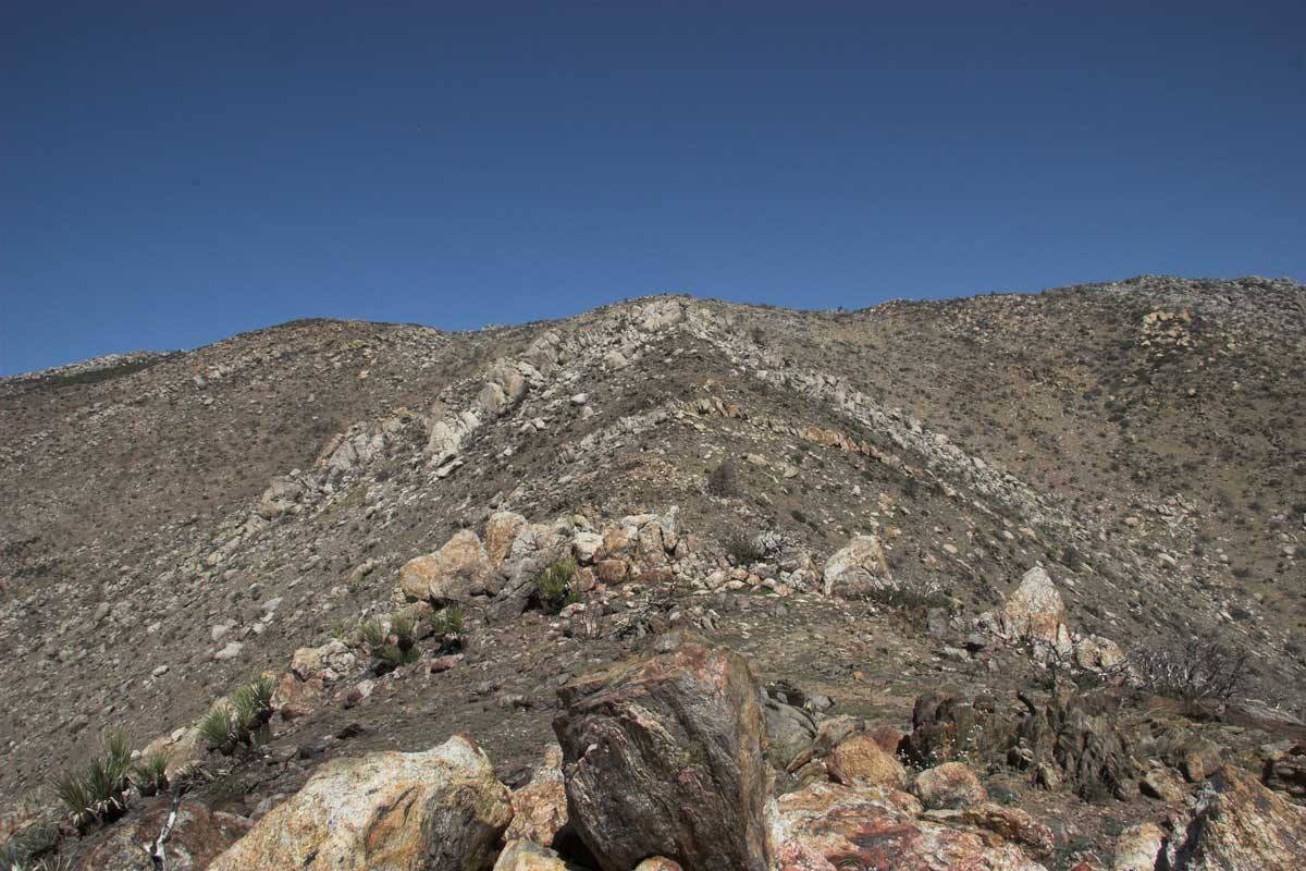
Nice! Found a firefighter burned handheld radio up near the ridgeline a while back. The Redmans mines are always fun to explore. Theres a Geocache next to the V shaped rock formation near the ridgeline also. That hike is a tough one for me.
--
Cant drive 55
Britain
http://icorva.com
|
|
|
+1
link
|
|
Rocko1 Posts: 615
12/12/2019
|
Britain wrote:
Nice! Found a firefighter burned handheld radio up near the ridgeline a while back. The Redmans mines are always fun to explore. Theres a Geocache next to the V shaped rock formation near the ridgeline also. That hike is a tough one for me.
Interesting. There are quite a few decent camp spots as you move up the ridge. Would be a good 2 day hike as well. It would be nice to see the sunrise from that ridge.
|
|
|
link
|
|
Britain Posts: 609
12/12/2019
|
Rocko1 wrote:
Britain wrote:
Nice! Found a firefighter burned handheld radio up near the ridgeline a while back. The Redmans mines are always fun to explore. Theres a Geocache next to the V shaped rock formation near the ridgeline also. That hike is a tough one for me.
Interesting. There are quite a few decent camp spots as you move up the ridge. Would be a good 2 day hike as well. It would be nice to see the sunrise from that ridge.
I did my hike when I was 61. I got to the ridgeline and at the base of the rocky final and ran out of steam. I should have just finished it.
This is a photo about 1/4 mile past the old bed.

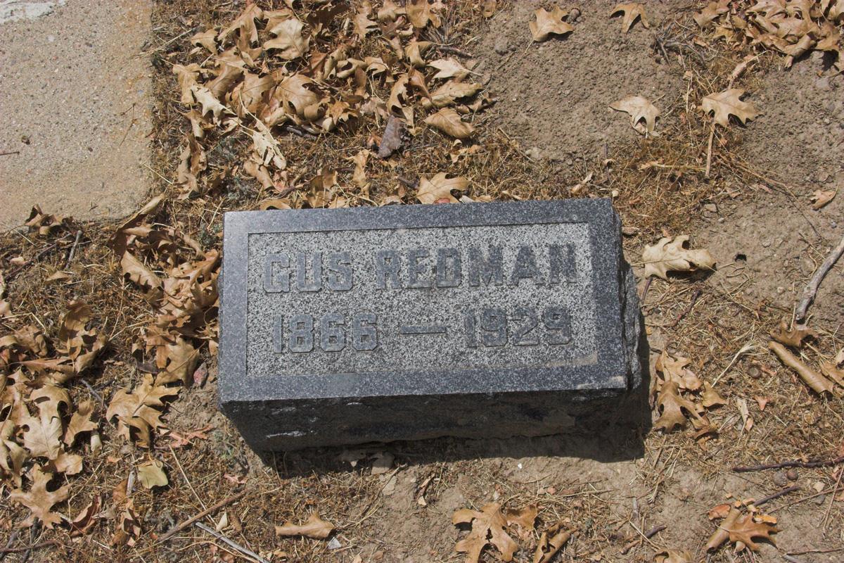
Gus is buried in the Julian cemetery.
 Geo next to this formation at the bottom Geo next to this formation at the bottom

Its a fun place would be good for a 2 dayer
--
Cant drive 55
Britain
http://icorva.com
|
|
|
+1
link
|
|
Rocko1 Posts: 615
12/12/2019
|
Britain wrote:
Rocko1 wrote:
Britain wrote:
Nice! Found a firefighter burned handheld radio up near the ridgeline a while back. The Redmans mines are always fun to explore. Theres a Geocache next to the V shaped rock formation near the ridgeline also. That hike is a tough one for me.
Interesting. There are quite a few decent camp spots as you move up the ridge. Would be a good 2 day hike as well. It would be nice to see the sunrise from that ridge.
I did my hike when I was 61. I got to the ridgeline and at the base of the rocky final and ran out of steam. I should have just finished it.
This is a photo about 1/4 mile past the old bed.

Gus is buried in the Julian cemetery.
 Geo next to this formation at the bottom Geo next to this formation at the bottom

Its a fun place would be good for a 2 dayer
I missed that rock! Very cool area. Such great views from that ridge.
|
|
|
link
|
|
rockhopper Posts: 672
12/12/2019
|
I am guessing they were mining for Gold? Looks like the same schist formation found in Julian hard rock mining. Nice hike! I really enjoyed hiking all over Granite form the East, West and South. A North approach would be a challenge. Mainly a parking challenge. Where to park your rig? Granite side note: A geologist suggested the Granite mountain was part of the Laguna range and was detached as a fault block and slid away as part of the Salton sink pull apart basin tectonic plate movement, Wow!
|
|
|
+1
link
|
|
ziphius Posts: 911
12/12/2019
|
Nice photos + trip. I bet you're the 1st person to carry a chair up to Granite. 
--
http://www.coyotelearning.org
|
|
|
+1
link
|
|
Rocko1 Posts: 615
12/12/2019
|
rockhopper wrote:
I am guessing they were mining for Gold? Looks like the same schist formation found in Julian hard rock mining. Nice hike! I really enjoyed hiking all over Granite form the East, West and South. A North approach would be a challenge. Mainly a parking challenge. Where to park your rig? Granite side note: A geologist suggested the Granite mountain was part of the Laguna range and was detached as a fault block and slid away as part of the Salton sink pull apart basin tectonic plate movement, Wow!
I parked off S2 and drove up the Mason Valley Wash just a bit. 33.0104, -116.4605.
On Monday I did a long hike on the north side of Granite on the PCT headed towards Cuyamaca. Was looking for routes up that side but the brush is pretty substantial as are the boulders in the washes. Would have to be from north west-I thought I saw a couple of viable options although much steeper than where I went up.
|
|
|
+1
link
|
|
tommy750 Posts: 1071
12/12/2019
|
Nice TR. Never been up Granite. BTW, who is Norman Glover??
|
|
|
link
|
|
deborah Posts: 115
12/12/2019
|
Thanks for posting. It looks really interesting. I like the pictures and commentary. 
|
|
|
+1
link
|
|
Rocko1 Posts: 615
12/13/2019
|
ziphius wrote:
Nice photos + trip. I bet you're the 1st person to carry a chair up to Granite. 
Thanks. Probably! Was itching to try it out.
|
|
|
link
|
|
Rocko1 Posts: 615
12/13/2019
|
tommy750 wrote:
Nice TR. Never been up Granite. BTW, who is Norman Glover??
Thanks. I would suggest this route. Very enjoyable, plenty of good spots for breaks, etc. Really enjoyed the section with the dense cactus. One of the thicker cactus forests I have seen in AB.

edited by Rocko1 on 12/13/2019
|
|
|
link
|
|
tekewin Posts: 385
12/16/2019
|
Yeah, I haven't seen as much cactus anywhere else...

|
|
|
+1
link
|
|
Rocko1 Posts: 615
12/16/2019
|
tekewin wrote:
Yeah, I haven't seen as much cactus anywhere else...

That's a great picture illustrating how dense this section is. I am fascinated about how some area can be so fertile and seem to have the perfect properties for grows like this and just a few yards away over the hill can be barren and barely anything will thrive.
|
|
|
link
|
|
rockhopper Posts: 672
12/18/2019
|
Looking more and more like Baja California. Makes sense since the Deserts globally have moved North about 100 miles in the past 100 years.
BTW did we determine what Mr Redmond was mining?
|
|
|
+1
link
|
|
Rocko1 Posts: 615
12/18/2019
|
rockhopper wrote:
Looking more and more like Baja California. Makes sense since the Deserts globally have moved North about 100 miles in the past 100 years.
BTW did we determine what Mr Redmond was mining?
From what I have read it was gold.
|
|
|
link
|
|
Britain Posts: 609
12/18/2019
|
rockhopper wrote:
Looking more and more like Baja California. Makes sense since the Deserts globally have moved North about 100 miles in the past 100 years.
BTW did we determine what Mr Redmond was mining?
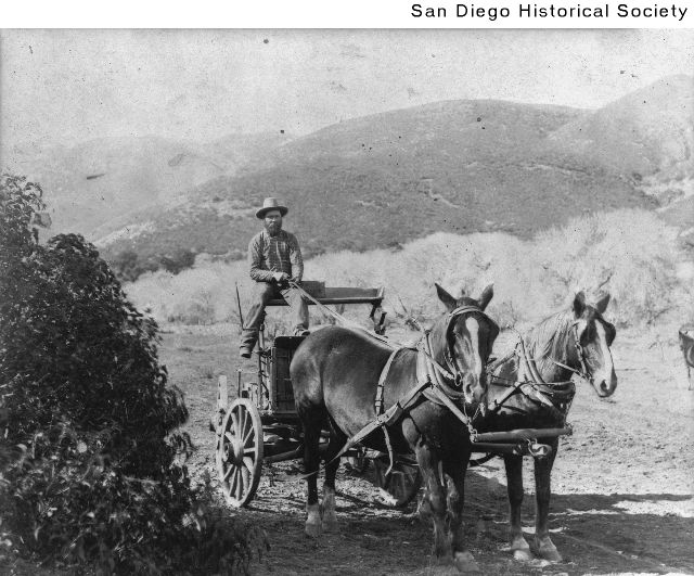
Yes gold. Gus Redman worked the mine sold it and bought it back. I believe his wife's brother found the first gold at Chariot.
Only picture of Redman I could uncover.

edited by Britain on 12/18/2019
--
Cant drive 55
Britain
http://icorva.com
|
|
|
+1
link
|
|
Rocko1 Posts: 615
12/18/2019
|
Britain wrote:
rockhopper wrote:
Looking more and more like Baja California. Makes sense since the Deserts globally have moved North about 100 miles in the past 100 years.
BTW did we determine what Mr Redmond was mining?
Yes gold. Gus Redman worked the mine sold it and bought it back. I believe his wife's brother found the first gold at Chariot.
Only picture of Redman I could uncover.

edited by Britain on 12/18/2019
I couldn't find anymore info on Redman either. I did see this PDF article that talked about mines in Julian/Cuyamaca and surrounding areas in the 1870's. Interesting stuff. Just search for keywords-Julian- as the pdf is quite large.
https://www.google.com/url?sa=t&rct=j&q=&esrc=s&source=web&cd=3&ved=2ahUKEwiHq9Lnh8DmAhXD3J4KHRLIDTgQFjACegQIBBAE&url=https%3A%2F%2Fwww.blm.gov%2Fdownload%2Ffile%2Ffid%2F29130&usg=AOvVaw0Yz9H03KfM--pbclhhbXHV
|
|
|
link
|
|
Scooter Posts: 114
12/18/2019
|
The Redman mine was gold. If you go into the Mine shafts above the buildings they are solid Julian Schist which is the Material they looked for to find gold. It is usually a grayish rock with flecks
|
|
|
+1
link
|
|
dsefcik Administrator Posts: 2634
12/20/2019
|
This post was a great history lesson...and great photos...!
--
http://www.sefcik.com
http://www.darensefcik.com
http://www.carrizogorge.com
|
|
|
+1
link
|