|
Brian Posts: 251
3/12/2024
|
I would like to attempt Rosa before the season is over. This would be an out and back, not one of the loop hikes. I downloaded some tracks from Peakbagger and it looks like there are a few different routes people take. I've been to Pyramid before and was originally planning to do that again and go up from there. But after looking at the tracks, it looks like it's more direct to go up the ridge to the W of Palo Verde canyon. One thing I'm undecided on is the final approach ridge. Looks like there are 2 options (represented by the yellow and red tracks in the pic). For anyone who has done both, which do you think is better/easier?

|
|
|
link
|
|
Buford Posts: 467
3/12/2024
|
I've done Rosa twice, both times as a loop starting with Pyramid, Rosa, Mile High, and Villager once.
There is a well defined trail from just north of pyramid to where the red and green lines meet. The trail follows the ridge or just off it. From where the red and green lines meet, the ascent is completely off trail. I don't remember it being particularly bad. Just steep and rocky like the rest of the desert.
I believe there is an old native american trail that goes from your "trail to Rosa" mark to the green line, if you can find it. I can't remember exactly which saddle it connects to.
--
Links to my photos: ABDSP photos, Bighorn sheep photos, ABDSP time lapse video, Wildlife photos (mainly birds)
|
|
|
link
|
|
Brian Posts: 251
3/12/2024
|
Thanks Buford, that's good info.
|
|
|
link
|
|
Buford Posts: 467
3/13/2024
|
Good luck if you go for it.
I haven't done the yellow route on your map, can't comment on if it is better or worse.
Here is the approximate route I did both times. I took the miners trail from Palo Verde to Smoke Tree. If you don't do Pyramid, there is a native american trail that climbs from the the bottom of Smoke Tree on the west side of Pyramid and joins the ridgeline somewhere north of the peak before Marble. The benefit is once you gain the Pyramid ridgeline it is relatively easy going until the final climb to Rosa.
Don't know how all the old native american and miners trails have held up with some of the rain. Some were already hard to find and follow a couple years ago.

--
Links to my photos: ABDSP photos, Bighorn sheep photos, ABDSP time lapse video, Wildlife photos (mainly birds)
|
|
|
link
|
|
Brian Posts: 251
3/14/2024
|
I made an attempt this morning, using the route that goes up Palo Verde canyon (this starts the same as Schad's route to Mile High). I was heavily influenced by this trip report since it said they made it to Rosa in 4 hours.
https://www.sdpeakbagger.com/2019/11/27/mile-high-mountain/
That's where I got the red track line on my map.
I made it as far as the ridge line above Palo Verde, but then I was facing a narrow ridge with steep dropoffs on both sides. My fear of heights kicked in. It didn't help that the forecast for the Santa Rosas called for possible gusts of up to 70 MPH.
I should have done the Pyramid route. I've summited Pyramid before, so I know I can make it that far. Next time.
|
|
|
+1
link
|
|
dsefcik Administrator Posts: 2634
3/15/2024
|
At least you gave it a go and spent the day out in the desert....now you have an excuse to go again..!
--
http://www.sefcik.com
http://www.darensefcik.com
http://www.carrizogorge.com
|
|
|
+2
link
|
|
Brian Posts: 251
3/16/2024
|
dsefcik wrote:
At least you gave it a go and spent the day out in the desert....now you have an excuse to go again..!
Exactly. It was a nice day and I used the extra time to check out the section of Coyote Canyon road between the gate closure and boulder alley.
My nemesis

Unlucky former resident of Palo Verde Canyon

They weren't kidding about Coyote Creek taking over the road

Boulder alley is back to looking the way it did in 2012

|
|
|
+1
link
|
|
dsefcik Administrator Posts: 2634
3/16/2024
|
You coulda taken that ridgeline, there is even a trail on it...🙂
--
http://www.sefcik.com
http://www.darensefcik.com
http://www.carrizogorge.com
|
|
|
+1
link
|
|
Scooter Posts: 114
3/16/2024
|
That happens, makes you want to go back even more !
|
|
|
link
|
|
Rocko1 Posts: 617
3/18/2024
|
Brian wrote:
dsefcik wrote:
At least you gave it a go and spent the day out in the desert....now you have an excuse to go again..!
Exactly. It was a nice day and I used the extra time to check out the section of Coyote Canyon road between the gate closure and boulder alley.
My nemesis
Unlucky former resident of Palo Verde Canyon
They weren't kidding about Coyote Creek taking over the road
Boulder alley is back to looking the way it did in 2012
That ridge is calling my name!
|
|
|
link
|
|
Brian Posts: 251
3/18/2024
|
Rocko1 wrote:
That ridge is calling my name!
I'd try it again if I had you along for moral support. And if it wasn't super gusty.
|
|
|
+1
link
|
|
surfponto Administrator Posts: 1369
3/21/2024
|
Nice pictures
Yeah I kind of don't blame you since you were solo hiking.
Maybe we can get Daren to take a visit out west. 🤔
Brian wrote:
Rocko1 wrote:
That ridge is calling my name!
I'd try it again if I had you along for moral support. And if it wasn't super gusty.
edited by surfponto on 3/21/2024
--
https://www.anzaborrego.net/


|
|
|
link
|
|
Buford Posts: 467
3/24/2024
|
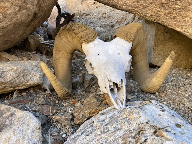
Nice ram skeleton.
I don't see any exposure on the ridge, I see a trail 
It's been windy most times I've been up in that area.
--
Links to my photos: ABDSP photos, Bighorn sheep photos, ABDSP time lapse video, Wildlife photos (mainly birds)
|
|
|
+1
link
|
|
Brian Posts: 251
2/3/2025
|
11 months later I returned to the trail to Rosa with a better forecast, a co-pilot and a lot more determination. I started up the same ridge as last time (the one that climbs out of Palo Verde canyon). There was some exposure but nothing worse than the trail to Villager. I was still undecided about the yellow or red route for the final ridge. When I got to a point where I could see both, the red looked like the better option despite adding a bit of mileage.
I often don't bother signing registers, but I was planning to for Rosa. Unfortunately the books were waterlogged despite being in an ammo can. Too bad because it looked like there are entries going back to at least the 80s. Not sure if they are ruined or if they can be salvaged once they dry out.
We went to Pyramid on the return, then I opted to follow Smoke Tree wash all the way to S-22 and road walk back to my car at Palo Verde wash. I've done the Miner's trail before, so I know we could have done that. My decision to go the longer but easier way was influenced by the fact I got pretty banged up during a fall on my way down from Pyramid.

My co-pilot Rodny and I on Rosa peak

Rodny with Mile High and Rabbit in the background

views from the top weren't great because of all the haze

|
|
|
+1
link
|
|
dtoujours Posts: 35
2/3/2025
|
Congratulations, I hope you get healed up quickly from your fall!
|
|
|
link
|
|
Rocko1 Posts: 617
2/4/2025
|
That's a big hike. Congrats.
|
|
|
link
|
|
Buford Posts: 467
2/5/2025
|
Nice work. Rosa is not easy to get to. Didn’t want to add on Mile High since you were right there?
I think I know where that ram skull is. Near the bottom of a wash as an ancient trail climbs out?
--
Links to my photos: ABDSP photos, Bighorn sheep photos, ABDSP time lapse video, Wildlife photos (mainly birds)
|
|
|
link
|
|
Brian Posts: 251
2/5/2025
|
Buford wrote:
Didn’t want to add on Mile High since you were right there?
Next time. Now that I know the neighborhood.
Buford wrote:
I think I know where that ram skull is. Near the bottom of a wash as an ancient trail climbs out?
Yes. Rodny posted a pic of it on an Anza Borrego Facebook group and from some of the comments it sounds like it's been there for at least 12 years and is named Herman.
|
|
|
+1
link
|
|
tekewin Posts: 386
2/16/2025
|
Congrats! I haven't been to Rosa that way. I also went from Pyramid. Love the ram skull.
|
|
|
+1
link
|