|
surfponto Administrator Posts: 1369
4/15/2012
|
Met Daren out for a day of hiking on the Island. The Island is the huge area of Desert surrounded on both sides by Interstate 8.
Pretty interesting spot with lots to see.

Rest of the photos are here
<em>edited by surfponto on 4/16/2012</em>
--
https://www.anzaborrego.net/


|
|
|
link
|
|
hikerdmb Posts: 423
4/15/2012
|
Nice place to explore. It is a very interesting area for sure. I am glad you found Paola's backpack. She is a student in my class. I will be sure to show her the picture so she can claim it. A few years back we drove the old 80 to where it ends at a cliff above I-8. I couldn't believe there were no markings or warnings back then to let you know the road was ending.
|
|
|
link
|
|
surfponto Administrator Posts: 1369
4/16/2012
|
We counted at least 6 backpacks out there. Clothes, tires, water bottles and blankets.
We scaled up the ridge which was pretty easy which then opens into a huge sandy valley
Really nice area.
Do you know anything about the old cabin/shack out there?

hikerdmb wrote:
Nice place to explore. It is a very interesting area for sure. I am glad you found Paola's backpack. She is a student in my class. I will be sure to show her the picture so she can claim it. A few years back we drove the old 80 to where it ends at a cliff above I-8. I couldn't believe there were no markings or warnings back then to let you know the road was ending.
<em>edited by surfponto on 4/17/2012</em>
--
https://www.anzaborrego.net/


|
|
|
link
|
|
ziphius Posts: 911
4/16/2012
|
That looks like a nice unexplored 'niche'. What is the approx. height on the cabin remains? The photo perspective makes it look quite low. It could be an early 1900s structure, based on the foundation.
--
http://www.coyotelearning.org
|
|
|
link
|
|
surfponto Administrator Posts: 1369
4/16/2012
|
Actually once you stepped inside it was probably about head high.
Stove still somewhat intact.
Foundation (rock) is in fairly good shape.
ziphius wrote:
That looks like a nice unexplored 'niche'. What is the approx. height on the cabin remains? The photo perspective makes it look quite low. It could be an early 1900s structure, based on the foundation.
--
https://www.anzaborrego.net/


|
|
|
link
|
|
anutami Posts: 491
4/16/2012
|
Any sign of the bighorns that call the island their home?
|
|
|
link
|
|
surfponto Administrator Posts: 1369
4/16/2012
|
No unfortunately
That was our original plan.
No signs just a lot of Bighorn scat.
anutami wrote:
Any sign of the bighorns that call the island their home?
--
https://www.anzaborrego.net/


|
|
|
link
|
|
ziphius Posts: 911
4/16/2012
|
What is a good and safe access point to begin a hike into the area? Assuming no 4-wheel drive and a low-clearance sedan. Did you travel very far off-road to get into the area?
--
http://www.coyotelearning.org
|
|
|
link
|
|
surfponto Administrator Posts: 1369
4/16/2012
|
Mountain Palm Springs exit would be the easiest to start.
You could park right at the off ramp and hike in.
We drove a bit off-road to start our hike but it isn't really necessary. I was going to go a bit further but the trail got a little hairy.
Bob
ziphius wrote:
What is a good and safe access point to begin a hike into the area? Assuming no 4-wheel drive and a low-clearance sedan. Did you travel very far off-road to get into the area?
<em>edited by surfponto on 4/16/2012</em>
--
https://www.anzaborrego.net/


|
|
|
link
|
|
mrkmc Posts: 87
4/16/2012
|
Another area I still need to check out. There are 3 benchmarks "on the island" that I want to check out, Devil, Inko, and Pah
|
|
|
link
|
|
surfponto Administrator Posts: 1369
4/16/2012
|
Like Daren says. Its one of those places you drive by for years and wonder "I wonder what it is like over there?"
Glad we finally checked it out. Plenty to explore in that area.
mrkmc wrote:
Another area I still need to check out. There are 3 benchmarks "on the island" that I want to check out, Devil, Inko, and Pah
--
https://www.anzaborrego.net/


|
|
|
link
|
|
dsefcik Administrator Posts: 2633
4/16/2012
|
mrkmc wrote:
Another area I still need to check out. There are 3 benchmarks "on the island" that I want to check out, Devil, Inko, and Pah
What map do you see those on? My USGS topos only show 7 unamed BM's.
--
http://www.sefcik.com
http://www.darensefcik.com
http://www.carrizogorge.com
|
|
|
link
|
|
tommy750 Posts: 1070
4/16/2012
|
Nice trip. Have started a few hikes from Old Hwy 80 and crossed under the tunnel toward Boulder Creek and Myers Creek but never checked out the island. Is that For Sale sign still up? Assumed it was the ranch to the west but never called the number. I hear there's a pile of cars that went off I-8 over by the ranch. Actually saw a PU fly off a few years ago. Didn't end well.
|
|
|
link
|
|
dsefcik Administrator Posts: 2633
4/16/2012
|
tommy750 wrote:
Nice trip. Have started a few hikes from Old Hwy 80 and crossed under the tunnel toward Boulder Creek and Myers Creek but never checked out the island. Is that For Sale sign still up? Assumed it was the ranch to the west but never called the number. I hear there's a pile of cars that went off I-8 over by the ranch. Actually saw a PU fly off a few years ago. Didn't end well.
It was your picture of the shack that made us go..haha!! Yeah, the for sale sign is still there but is flipped around and facing east. I think the SPL project must have done it.
--
http://www.sefcik.com
http://www.darensefcik.com
http://www.carrizogorge.com
|
|
|
link
|
|
dsefcik Administrator Posts: 2633
4/16/2012
|
Here are a few pics I took while out with Bob
Ocotillo's are blooming great right now

Fishhook Cactus

The Culvert

See any footprints??

Bob for size reference

We think this is a Hawk, I blame the SPL Project

Lupine in the wash

Old oil can that was smashed and nailed to a post at the shack

Some pics of the shack

Hey, nice view of the Sunrise Power Link tower in the background. Love those scenic back country views.

---

Up at the top of the saddle looking towards Myer Valley, it almost has sand dunes there is so much sand

Bob had to leave before I did so I had a few hours left and decided to go check out the Stage Station Historical Marker on the topo map, I have been wanting to go see that for some time now

This is about all I found though, I didn't see anything else and according to my GPS I was standing right on it.

There were some palms and a spring there though, that was pretty cool. These palms are right below the freeway, you can pull over and look down at them.

Here is the spring, it had some plumbing that was no longer hooked up. The water was flowing though and there were plenty of bees and birds everywhere

The Mighty Palms

Here is a panorama of Devils Canyon Bridge from down in Devils Canyon. Download the original (36mb)

<em>edited by dsefcik on 4/16/2012</em>
--
http://www.sefcik.com
http://www.darensefcik.com
http://www.carrizogorge.com
|
|
|
link
|
|
tommy750 Posts: 1070
4/16/2012
|
I stumbled on that cabin in 2005 heading out to Myers Valley. Stopped by last December and it looked about the same. If you have a copy of Chris Wray's "The Historic Backcountry," it has a blurb on this cabin and mentions another a little way down I-8, one I've never seen. It's listed as being at 32 40.39, -116 04.40. On Google Earth, looks like it's on a little rise near where a dirt road peels off the eastbound lanes.
|
|
|
link
|
|
dsefcik Administrator Posts: 2633
4/16/2012
|
tommy750 wrote:
I stumbled on that cabin in 2005 heading out to Myers Valley. Stopped by last December and it looked about the same. If you have a copy of Chris Wray's "The Historic Backcountry," it has a blurb on this cabin and mentions another a little way down I-8, one I've never seen. It's listed as being at 32 40.39, -116 04.40. On Google Earth, looks like it's on a little rise near where a dirt road peels off the eastbound lanes.
Thanks for that info...maybe I missed something but those coordinates put a marker right at the shack we have posted pics of. I will look and see if I can find his book.
--
http://www.sefcik.com
http://www.darensefcik.com
http://www.carrizogorge.com
|
|
|
link
|
|
tommy750 Posts: 1070
4/17/2012
|
dsefcik wrote:
tommy750 wrote:
I stumbled on that cabin in 2005 heading out to Myers Valley. Stopped by last December and it looked about the same. If you have a copy of Chris Wray's "The Historic Backcountry," it has a blurb on this cabin and mentions another a little way down I-8, one I've never seen. It's listed as being at 32 40.39, -116 04.40. On Google Earth, looks like it's on a little rise near where a dirt road peels off the eastbound lanes.
Thanks for that info...maybe I missed something but those coordinates put a marker right at the shack we have posted pics of. I will look and see if I can find his book.
Oops! You're absolutely right. The other site is 32 41.42 -116 3.68
|
|
|
link
|
|
mrkmc Posts: 87
4/17/2012
|
dsefcik wrote:
What map do you see those on? My USGS topos only show 7 unamed BM's.
They are not on the map. You can find a list of all the stations for each quad using the ngs website. (for some reason I cant link to the list generated or the data sheets) But follow the links on that site: Survey Marker Data Sheets> Data Sheets> USGS Quad> then enter In-Ko-Pah Gorge. Once you get to the list, you can select the station you want and tget the data sheet, which gives a writen description on how to locate the BM.
<em>edited by mrkmc on 4/17/2012</em>
|
|
|
link
|
|
dsefcik Administrator Posts: 2633
4/17/2012
|
mrkmc wrote:
They are not on the map. You can find a list of all the stations for each quad using the ngs website. (for some reason I cant link to the list generated or the data sheets) But follow the links on that site: Survey Marker Data Sheets> Data Sheets> USGS Quad> then enter In-Ko-Pah Gorge. Once you get to the list, you can select the station you want and tget the data sheet, which gives a writen description on how to locate the BM.
Very cool, they even have shapefiles..thanks! Caltopo is stepping it up a bit also, thanks for the tips!
--
http://www.sefcik.com
http://www.darensefcik.com
http://www.carrizogorge.com
|
|
|
link
|
|
surfponto Administrator Posts: 1369
4/17/2012
|
Thanks for the tip Tommy750,
You also inspired another one of my trips up the East Fork of Carrizo Gorge a few years back.
Welcome to the forum
Bob
tommy750 wrote:
I stumbled on that cabin in 2005 heading out to Myers Valley. Stopped by last December and it looked about the same. If you have a copy of Chris Wray's "The Historic Backcountry," it has a blurb on this cabin and mentions another a little way down I-8, one I've never seen. It's listed as being at 32 40.39, -116 04.40. On Google Earth, looks like it's on a little rise near where a dirt road peels off the eastbound lanes.
--
https://www.anzaborrego.net/


|
|
|
link
|
|
surfponto Administrator Posts: 1369
4/17/2012
|
The saddle up at the start of Myer Valley is really nice. Will have to go back there and explore some more
I have heard the old highway just ends with no warning.
that is crazy..... 
Bob
tommy750 wrote:
Nice trip. Have started a few hikes from Old Hwy 80 and crossed under the tunnel toward Boulder Creek and Myers Creek but never checked out the island. Is that For Sale sign still up? Assumed it was the ranch to the west but never called the number. I hear there's a pile of cars that went off I-8 over by the ranch. Actually saw a PU fly off a few years ago. Didn't end well.
<em>edited by surfponto on 4/17/2012</em>
--
https://www.anzaborrego.net/


|
|
|
link
|
|
tommy750 Posts: 1070
4/17/2012
|
surfponto wrote:
Thanks for the tip Tommy750,
You also inspired another one of my trips up the East Fork of Carrizo Gorge a few years back.
Welcome to the forum
Bob
Thanks! You guys have already got me out to see the petroglyphs at Indian Hill and Carrizo Canyon. Tried finding the Summer Solstice Cave from McCain Valley but whiffed on that one.
|
|
|
link
|
|
dsefcik Administrator Posts: 2633
4/17/2012
|
tommy750 wrote:
Oops! You're absolutely right. The other site is 32 41.42 -116 3.68
Great, I have that marked for my next trip out there. I have been wanting to go up that wash anyway (among 5 million others also). It seems that Chris Wray's book is a little hard to find. I wonder if the Butterfield Ranch store or the visitor center has it. The Butterfield store has some pretty funky old books on it's shelf by the register.
--
http://www.sefcik.com
http://www.darensefcik.com
http://www.carrizogorge.com
|
|
|
link
|
|
surfponto Administrator Posts: 1369
4/17/2012
|
Here you go Daren
Seller is actually the author Chris Wray 
dsefcik wrote:
tommy750 wrote:
Oops! You're absolutely right. The other site is 32 41.42 -116 3.68
Great, I have that marked for my next trip out there. I have been wanting to go up that wash anyway (among 5 million others also). It seems that Chris Wray's book is a little hard to find. I wonder if the Butterfield Ranch store or the visitor center has it. The Butterfield store has some pretty funky old books on it's shelf by the register.
--
https://www.anzaborrego.net/


|
|
|
link
|
|
dsefcik Administrator Posts: 2633
4/17/2012
|
surfponto wrote:
Here you go Daren
Seller is actually the author Chris Wray 
http://tierrablancabooks.com/retailers.htm
Looks like he has his own website, I may just email him and see if I can pick it up locally, or stop at the Desert Tower..haha...thanks Bob!
--
http://www.sefcik.com
http://www.darensefcik.com
http://www.carrizogorge.com
|
|
|
link
|
|
tommy750 Posts: 1070
4/17/2012
|
dsefcik wrote:
surfponto wrote:
Here you go Daren
Seller is actually the author Chris Wray 
http://tierrablancabooks.com/retailers.htm
Looks like he has his own website, I may just email him and see if I can pick it up locally, or stop at the Desert Tower..haha...thanks Bob!
Got my copy at the Desert View Tower.
|
|
|
link
|
|
dsefcik Administrator Posts: 2633
4/17/2012
|
tommy750 wrote:
I hear there's a pile of cars that went off I-8 over by the ranch. Actually saw a PU fly off a few years ago. Didn't end well.
Check the pictures on this website, scroll down about 3/4 of the way: http://nexthill.com/Photo's/Devils%20Canyon/index.htm
--
http://www.sefcik.com
http://www.darensefcik.com
http://www.carrizogorge.com
|
|
|
link
|
|
tommy750 Posts: 1070
4/17/2012
|
dsefcik wrote:
tommy750 wrote:
I hear there's a pile of cars that went off I-8 over by the ranch. Actually saw a PU fly off a few years ago. Didn't end well.
Check the pictures on this website, scroll down about 3/4 of the way: http://nexthill.com/Photo's/Devils%20Canyon/index.htm
Thanks. Those vehicles look like they sailed off Old Hwy 80 some years ago.
|
|
|
link
|
|
tommy750 Posts: 1070
11/23/2012
|
Daren Sefcik wrote:
tommy750 wrote:
Oops! You're absolutely right. The other site is 32 41.42 -116 3.68
Great, I have that marked for my next trip out there. I have been wanting to go up that wash anyway (among 5 million others also). It seems that Chris Wray's book is a little hard to find. I wonder if the Butterfield Ranch store or the visitor center has it. The Butterfield store has some pretty funky old books on it's shelf by the register.
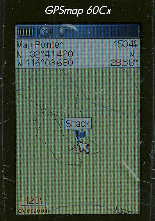
Daren, I know you posted on going out to find this cabin but I don't recall what topic it was under. Anyway, stopped by on my way down the grade today and the road was as you described, 4X4 only. Made it to the little plateau but wasn't able to find any signs of a cabin. Had my GPS on with coordinates from Chris Wray's book but nothing. Tom
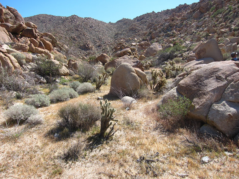
Just before the site, a BLM greeting.

Wilderness by tomteske, on Flickr
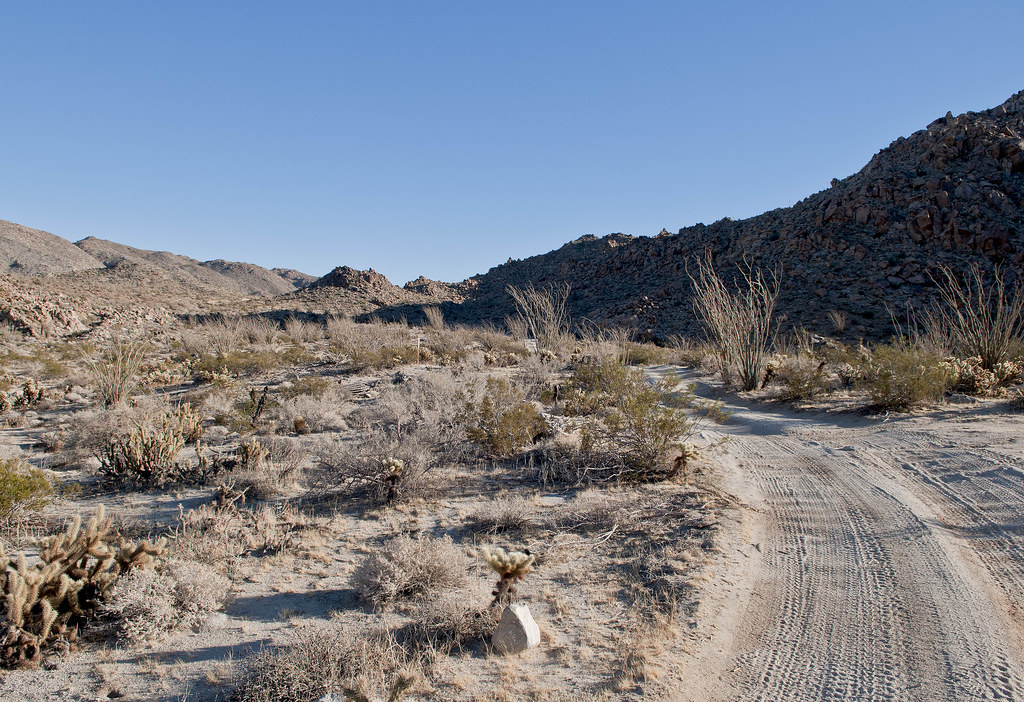
The shack is supposed to be just to the left of the road.

Lower Miner's Shack Site by tomteske, on Flickr
GPS

Shack GPS by tomteske, on Flickr
|
|
|
link
|
|
dsefcik Administrator Posts: 2633
11/26/2012
|
@Tom:
Yeah, that's pretty much what I saw. When I got to the BLM WIlderness markers I parked and started looking around. BP were on me in minutes both times I stopped out there. Just to the right of your photo was where I found the backpacks with the frijoles in a bag.
--
http://www.sefcik.com
http://www.darensefcik.com
http://www.carrizogorge.com
|
|
|
link
|
|
Space Cowboy Posts: 9
4/9/2013
|
There's a historical marker for the old stage coach station up at the Desert View Tower. I suspect they moved the marker from its original spot to there when they put in the freeway. Although, I remember seeing the marker/monument there as early as 1964. The freeway wasn't completed yet, I don't think, but maybe someone was thinking ahead.
Now, does anyone know what's going on at Mountain Springs, the town, I mean. Its one of the few ghost towns that I know of with its own interstate off-ramp. I would love to walk through there. Some of those structures I remember being a bar and store in the '60's.
edited by Space Cowboy on 4/9/2013
|
|
|
link
|
|
surfponto Administrator Posts: 1369
4/9/2013
|
It is an interesting area for sure. Enjoyed exploring it with Daren last year.
Myer Valley Hike
I have yet to check out the Desert Tower. Always seems we are rushing to get out to Borrego and then on the way home we are too tired. 
Space Cowboy wrote:
There's a historical marker for the old stage coach station up at the Desert View Tower. I suspect they moved the marker from its original spot to there when they put in the freeway. Although, I remember seeing the marker/monument there as early as 1964. The freeway wasn't completed yet, I don't think, but maybe someone was thinking ahead.
Now, does anyone know what's going on at Mountain Springs, the town, I mean. Its one of the few ghost towns that I know of with its own interstate off-ramp. I would love to walk through there. Some of those structures I remember being a bar and store in the '60's.
edited by Space Cowboy on 4/9/2013
--
https://www.anzaborrego.net/


|
|
|
link
|
|
dsefcik Administrator Posts: 2633
4/9/2013
|
There are no trespassing signs on the roads going to the buildings. I hiked around them to get to the palms and the historic marker location. Along the old road down the middle it is nothing but sections of shooting debris left by thoughtless target shooters. I have been there twice when Border Patrol agents were putting undocumented folks into their vehicles.
Space Cowboy wrote:
There's a historical marker for the old stage coach station up at the Desert View Tower. I suspect they moved the marker from its original spot to there when they put in the freeway. Although, I remember seeing the marker/monument there as early as 1964. The freeway wasn't completed yet, I don't think, but maybe someone was thinking ahead.
Now, does anyone know what's going on at Mountain Springs, the town, I mean. Its one of the few ghost towns that I know of with its own interstate off-ramp. I would love to walk through there. Some of those structures I remember being a bar and store in the '60's.
edited by Space Cowboy on 4/9/2013
--
http://www.sefcik.com
http://www.darensefcik.com
http://www.carrizogorge.com
|
|
|
link
|
|
tommy750 Posts: 1070
4/9/2013
|
dsefcik wrote:
There are no trespassing signs on the roads going to the buildings. I hiked around them to get to the palms and the historic marker location. Along the old road down the middle it is nothing but sections of shooting debris left by thoughtless target shooters. I have been there twice when Border Patrol agents were putting undocumented folks into their vehicles.
Space Cowboy wrote:
There's a historical marker for the old stage coach station up at the Desert View Tower. I suspect they moved the marker from its original spot to there when they put in the freeway. Although, I remember seeing the marker/monument there as early as 1964. The freeway wasn't completed yet, I don't think, but maybe someone was thinking ahead.
Now, does anyone know what's going on at Mountain Springs, the town, I mean. Its one of the few ghost towns that I know of with its own interstate off-ramp. I would love to walk through there. Some of those structures I remember being a bar and store in the '60's.
edited by Space Cowboy on 4/9/2013
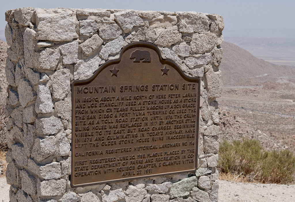
This is the new (1991) plaque at Desert Tower.

Mountain Springs Station Site by tomteske, on Flickr
Best description of what's going on at Mountain Spring is in Chris Wray's "The Historic Backcountry." Apparently McDonald Service Station from the '30's evolved into the cluster of buildings you now see. Think that whole place has been for sale for a few years. Have written the real estate agent's number down a few times just to call and see what's going on but have never done it. Remains of a stone corral are visible to the west of I-8 at where a dirt road drops in from Table Mt. Need to check it out. Tom
|
|
|
link
|
|
dsefcik Administrator Posts: 2633
1/28/2015
|
tommy750 wrote:
I stumbled on that cabin in 2005 heading out to Myers Valley. Stopped by last December and it looked about the same. If you have a copy of Chris Wray's "The Historic Backcountry," it has a blurb on this cabin and mentions another a little way down I-8, one I've never seen. It's listed as being at 32 40.39, -116 04.40. On Google Earth, looks like it's on a little rise near where a dirt road peels off the eastbound lanes. While researching for an upcoming trip I saw in the Lindsay book that he mentions this shack was called by some the "Recluse Cabin" and was built by a sheepherder from Holtville in the late 1940's or early 50's.
--
http://www.sefcik.com
http://www.darensefcik.com
http://www.carrizogorge.com
|
|
|
link
|