1/16/2024
Topic:
Indian Gorge Campout
Brian
|
Rocko1 wrote:
Nice boa. I have only seen one also, near Pinyon Mtn Rd years ago. Shockingly I see very few reptiles.

I saw one like that on my solo trip to Alta Seca Bench. Not sure whether I remembered to tell you about that when we went there. |
1/16/2024
Topic:
My Retriement
Brian
|
Great pics and I wish you luck in your new home. If you (when you're in town) or Gary would ever like a hiking companion, I'd like to apply for the position. |
1/21/2024
Topic:
Four Frogs Canyon
Brian
|
The Four Frogs / Jacumba Jim loop in Schad's book looks like a real slog (starts from the top in McCain Valley). I haven't ruled out doing it some day, but it's definitely not at the top of my list. Never thought of going up from the bottom. Anything interesting there? |
2/1/2024
Topic:
Sad News about Anza Borrego
Brian
|
https://theabf.org/coyotecanyon/?fbclid=IwAR10wGfpDTNV6xwX-E8oTH9IjHezzu_hefkgaAg1frVrFSVPdP9SgnmJTVw_aem_AbVH8XuZ26ONyXw95cAF01zTppguxg8ne9HXsOhZv7ShzGlYwAY6SahOfqJ3Hg9ZHrk
Looks like there is a plan to reopen the road, but it will take a while. |
2/3/2024
Topic:
Anza Borrego Egg Mountain
Brian
|
Nice pics. Sometimes the sky is so beautiful out there. |
2/12/2024
Topic:
Sandstone Canyon question
Brian
|
I might do that, but first I'm going to try doing a return trip to look again. I'll be better prepared next time. I think I've figured out where to look from the adjacent pics. |
2/14/2024
Topic:
Little Blair North
Brian
|
We only saw one other hiker. It's nice to know there are still places that offer some solitude without being too difficult to reach. |
2/18/2024
Topic:
Sandstone Canyon question
Brian
|
tommy750 wrote:
Nice find. Only issue I would have is what they're painted on. The last Kumeyaay (and Cahuilla) visited Hapaha just up the wash in the 1890's and I would wonder if it would last that long on exposed sandstone. The visitor grafitti etched into the neaby rocks seems to fade rather quickly but there's lots of paint on sanstone like stuff in Utah so who knows. Will see if anyone at BARC has seen that.
I had the same thought. That plus the fact that no one seems to know about this makes me wonder if it was a fake that was recently done at the time I saw it, and has weathered away in the 10 years since then. |
2/25/2024
Topic:
Sandstone Canyon question
Brian
|
update:
I returned to Sandstone Canyon this weekend and used identifiable features and timestamps from my 2014 photo series to find the spot where the pictographs had been. They are almost completely gone now. I had to get very close to see any traces which confirmed I was in the right spot.
The spot is tucked in under an overhanging ledge which would have protected it from rain. Having said that, the fact they disappeared in only 10 years suggests they couldn't have been very old.


 |
2/28/2024
Topic:
Greeting!
Brian
|
Welcome. What's your favorite hike in Anza Borrego? |
3/12/2024
Topic:
upcoming? Rosa (looking for advice)
Brian
|
I would like to attempt Rosa before the season is over. This would be an out and back, not one of the loop hikes. I downloaded some tracks from Peakbagger and it looks like there are a few different routes people take. I've been to Pyramid before and was originally planning to do that again and go up from there. But after looking at the tracks, it looks like it's more direct to go up the ridge to the W of Palo Verde canyon. One thing I'm undecided on is the final approach ridge. Looks like there are 2 options (represented by the yellow and red tracks in the pic). For anyone who has done both, which do you think is better/easier?
 |
3/12/2024
Topic:
upcoming? Rosa (looking for advice)
Brian
|
Thanks Buford, that's good info. |
3/14/2024
Topic:
upcoming? Rosa (looking for advice)
Brian
|
I made an attempt this morning, using the route that goes up Palo Verde canyon (this starts the same as Schad's route to Mile High). I was heavily influenced by this trip report since it said they made it to Rosa in 4 hours.
https://www.sdpeakbagger.com/2019/11/27/mile-high-mountain/
That's where I got the red track line on my map.
I made it as far as the ridge line above Palo Verde, but then I was facing a narrow ridge with steep dropoffs on both sides. My fear of heights kicked in. It didn't help that the forecast for the Santa Rosas called for possible gusts of up to 70 MPH.
I should have done the Pyramid route. I've summited Pyramid before, so I know I can make it that far. Next time. |
3/16/2024
Topic:
upcoming? Rosa (looking for advice)
Brian
|
dsefcik wrote:
At least you gave it a go and spent the day out in the desert....now you have an excuse to go again..!
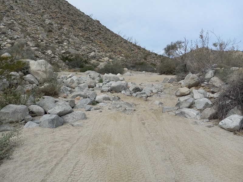
Exactly. It was a nice day and I used the extra time to check out the section of Coyote Canyon road between the gate closure and boulder alley.
My nemesis

Unlucky former resident of Palo Verde Canyon

They weren't kidding about Coyote Creek taking over the road

Boulder alley is back to looking the way it did in 2012
 |
3/18/2024
Topic:
upcoming? Rosa (looking for advice)
Brian
|
Rocko1 wrote:
That ridge is calling my name!
I'd try it again if I had you along for moral support. And if it wasn't super gusty. |
3/28/2024
Topic:
Panamint City
Brian
|
Not Anza Borrego, but I thought this trip report would still fit here.
I did a quick trip to Panamint City (Death Valley National Park) last week. Managed to get a weather window where the bottom of the hike was low 80s and the top was 60s in the day / 40s at night. Just a couple days later on the weekend, the forecast was for lows in the 20s. Glad I wasn't around for that.
This was my first time doing this hike after thinking about it for years. All of the challenges which I anticipated were there but not as bad as I feared. The road to the trailhead did have some spots that were marginal for a Subaru, but I still made it to the end. The parts where you have to walk in the stream and climb wet waterfalls were manageable. There is 3600' of gain, but that was also manageable. There was some minor bushwhacking.
The part I didn't expect - and my least favorite part of the hike - was that the last few miles which I anticipated would be on the former road often ended up in a dry rocky creek bed instead. That made for slow going and foot pain.
This used to be a road until it was washed out in 1983

Some trucks didn't make it out before the road turned into a waterfall

One of the better sections of the dry portion of the hike, after the initial 3 miles of jungly conditions

A couple views of the iconic smelter
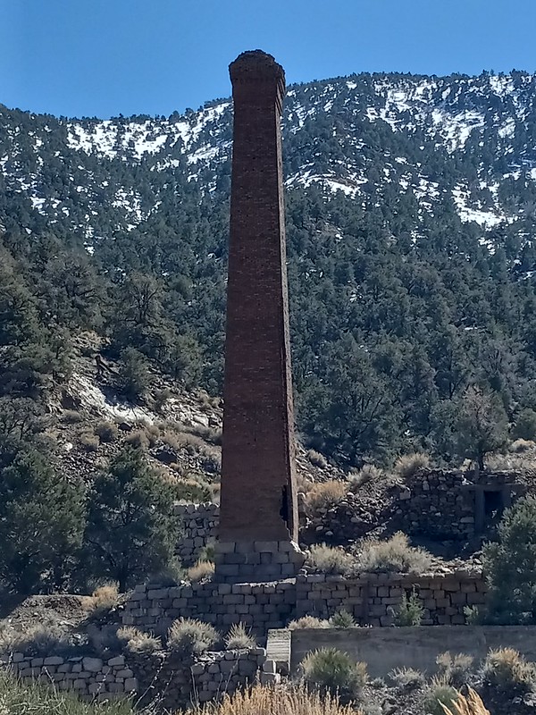

the "Panamint Hilton"

leftover equipment from the mining days


my accommodation for the night and town overview

 |
3/29/2024
Topic:
Middle Ysidro
Brian
|
Nice trip report. I made a half hearted attempt at the western summit last spring but ended up not wanting to deal with the amount of brush on the final approach to the ridge. |
4/12/2024
Topic:
Pinyon Wash to Harper Cabin
Brian
|
tekewin wrote:
Those blooms are amazing. Sounds like a successful trip and kudos for being kind to the biker.
Is the road OK all the way to Harper Flat or even Hapaha Flat? I've only been down that road a little ways to hike to Sunset Mountain.
That road ends at a canyon which is a short hike up to Harper Flat. The road that passes Harper Flat on the other side can be accessed 2 ways. One end goes in from Pinyon Mountain Road (which necessitates negotiating the squeeze and heart attack hill). The other end goes in from Fish Creek and passes through Hapaha Flat. The biggest obstacle I know of on that route comes just before you get to Hapaha and looks like this:
It's no longer legal to drive through Harper Flat (despite the fact someone did it last summer and was later found dead).
edited by Brian on 4/12/2024 |
4/12/2024
Topic:
Pinyon Wash to Harper Cabin
Brian
|
Britain wrote:
I always thought Harpers was a closed area for vehicles. Park maps show no vehicle trails in it. Weekend warriors.
Older topo maps do show a jeep trail going through Harpers, but it's been closed to vehicles for probably about 30 years. I hiked through there last September and saw the wheel tracks of the guy who drove in over the summer. He went around a fence that's supposed to keep it closed off from the main road. |
4/12/2024
Topic:
Pinyon Wash to Harper Cabin
Brian
|
tommy750 wrote:
Was able to find the Tacoma location on GE and the news reports gave info on where the individuals were located.
Wow, the Tacoma was located much further west than I imagined. I had assumed he had driven to a point much closer to Harper Canyon since that is the way he tried to get out. Would have been much easier for him if he had walked down to Pinyon Wash.
The truck hadn't been airlifted out last September when I was there, but I didn't see it. I must have been fairly close. I was taking a friend up that canyon from Pinyon Wash and then over to see the ruins of the cabin. If I had been by myself, I might have explored a bit more and followed the wheel tracks which were still fresh at the time. |
4/14/2024
Topic:
Pinyon Wash to Harper Cabin
Brian
|
Britain wrote:
Wasn't there some kid that took his dad's Tahoe stuck in the squeeze and disappeared years ago also?
Yep. I think he actually went in from the other end. From Fish Creek. But the truck was found near the bottom of heart attack hill and one of the tires was completely destroyed, so he wouldn't have been able to make it out that way even if that was a 2 way road (which it isn't). I first found out about that when I was looking at Google Earth to familiarize myself with the area and someone had posted a bunch of pics from the search for the kid. |
10/6/2024
Topic:
The Santa Rosas Sawmill Trail (Sort Of)
Brian
|
tommy750 wrote:
I definitely remember this hike! Have been thinking about it recently as the start (or end) of a Cactus Spring-Agua Alta-Stifferino-Cottonwood-New Santa Rosa-Toro loop. Maybe something like this? https://caltopo.com/m/1TVFE
I had considered that loop too. The only thing that gives me pause is that it seems like the stretch between Stifferino to Martinez Canyon to Horsethief Creek is a pretty long stretch with no reliable water source (AFAIK). But if you were planning to do it and wanted company, I would certainly be interested. I've hiked many individual sections of this but haven't connected them.
The more modest loop I have been thinking about would be to park at Toro, hike Alta Seca Bench then descend to Stifferino, then over to the Cottonwoods, then back up to Toro. Or the other way around. |
10/7/2024
Topic:
The Santa Rosas Sawmill Trail (Sort Of)
Brian
|
tommy750 wrote:
My understanding confirmed by Rockhopper a while back is the spring at Agua Alta was rehabbed and has a good flow. If that's no longer true, then you're right.
Oh wow, that would be amazing. I remember asking him about it here and he said it was a no go, but that would have been a few years ago. |
10/7/2024
Topic:
The Santa Rosas Sawmill Trail (Sort Of)
Brian
|
tommy750 wrote:
https://www.anzaborrego.net/anzaborrego/Forum/topic1438-martinez-peak-and-little-pinyon-flat.aspx
He mentions it here. I saw a video on YT showing a few seconds of the spring and it looked good. But all this was up to five years ago, so...
This is probably one of those cases of my memory being bad.
Anyway I hope you're able to do it this season. That route between Santa Rosa MTN and Nicholias Canyon looks especially interesting. I remember seeing that on the historic map. |
10/24/2024
Topic:
Indianhead East Ridge
Brian
|
I like that idea of exploring the same peak from different directions. Sombrero is the only one I can think of that I've done that with. Don't think I'll be doing Indianhead but I love seeing the reports.
edited by Brian on 10/24/2024 |
11/26/2024
Topic:
Hey there!
Brian
|
Welcome!
I'd be interested in hearing where you're thinking of going for your week long trip, if you're inclined to share. I usually don't go out for more than 1 or 2 nights myself due to the scarcity of water. |
12/8/2024
Topic:
Agua Alta overnight
Brian
|
Last weekend after Thanksgiving I did an overnight hike to Agua Alta spring. I was considering spending an extra day and doing a dayhike to Jack Miller cabin, but I would have needed to refill water at the spring for that. There was a small amount of water, but it was green and stagnant and there was no new flow coming in. It would have worked in an emergency, but for my purposes I decided to give it a miss. I had carried 6 liters which ended up being the right amount for my 2 day / one night trip.
I have a map published by the Santa Rosa and San Jacinto National Monument which lists the distance to Agua Alta as 8.8 miles, but according to my tracker it was a little over 10 from the Cactus Spring parking area. This map mentions that the trail becomes indistinct and hard to follow past Cactus Spring. It actually was easier than I was imagining. There were many sections that were well marked with cairns, but there were also sections (especially crossing washes) where it was easy to lose the trail and I was glad to have GPS.
I noticed that the trail on the "mapbuilder topo" layer of CalTopo didn't seem to be accurate past the 5168 saddle. There are a lot of straight lines with no regard to the topography. I used the "scanned topo" (USGS) layer which agreed with the cairns I was seeing.
This is near Cactus Spring and reminded me of similar rock piles I've seen in Rockhouse Valley. Burial mound?

Typical scenery along the way


Now that's a cairn!

backside of Toro

Shortly after cresting the 5168 saddle. The Salton Sea is sorta visible through the haze and the Santa Rosa crest is on the right

Agua Alta

A native site near the spring


 |
12/8/2024
Topic:
Ancient Giant Camel Track in Anza Borrego
Brian
|
Nice find! |
12/8/2024
Topic:
Piedras Grandes
Brian
|
I also hit 60 this year. I remember you had surgery a while back. It's great that you're getting back out there. Tough area. |
12/10/2024
Topic:
Wonderstone Wash & Lake Cahilla Bathtub Ring
Brian
|
Nice video. I remember seeing Wonderstone Wash mentioned in early editions of Schad's book. But I never wanted to deal with getting permission for access, so I never went there. Nice to see what it looks like. |
12/24/2024
Topic:
Agua Alta overnight
Brian
|
Last week I returned to try to finish the Cactus Spring trail by coming up from Martinez Canyon at the bottom end. I was hoping to once again reach Agua Alta spring so that I would have done the whole trail. It almost worked! By the time I set up camp I was only 1.5 miles from the spring, which normally would be a trivial distance to cover.
There were a couple reasons I didn't. The weather was hotter than expected and I had gone through half my water supply by the time I set up camp (I carried 7.5 liters and had used all of it by the time I got back to the car the next day. The car's thermometer said it was 81 degrees). Also, although I made good time going through Martinez canyon (6.7 miles to the turnoff in 3.5 hours), the next mile climbing out of Martinez took me 3 hours. I might not have always been exactly on the trail, but I was close and couldn't see any easier way. The hillside going up was not only steep but crumbly. There were a couple sections where I was on my hands and knees and even then I had trouble not sliding down. Every rock that I tried to grab would come loose and start rolling down. This section was equally difficult to descend the next day.
On the positive side, this was my second time doing Martinez Canyon and I enjoyed it much more than the first time I did it 4 years ago when I went to the Jack Miller cabin. On that occasion it took me quite a bit of time and frustration to get past the choke points of vegetation. Now that I know the route through there it was much easier. And this time the BLM gate was open and I was able to drive all the way to the wilderness boundary. But not without a stop on the way when I got stuck on a rock step (my first time getting seriously stuck with my Crosstrek - luckily the recovery gear I carry worked well).
There are 3 different wrecks just inside the BLM gate. How does one end up flipping a car in soft flat sand?

Someone apparently rode an E-bike at least as far as the reeds section of the canyon

The trail through the choke point

climbing out of Martinez

camp and sunrise the next morning


A distant view of Tahquitz spring. I didn't want to make the detour up the river bed on this occasion. Anyone know if it's active?
 |
12/29/2024
Topic:
Agua Alta overnight
Brian
|
Yeah, it wasn't like that video. There was no new flow coming in at all. Horsethief creek was dryer than normal too, but did have enough to be a viable source.
That's good to know about RHC. I plan to get out there some time in the next couple months and it's good to know what to expect. |
12/29/2024
Topic:
Pinyon Ridge and The Guzzler
Brian
|
We started from the Wilson Peak TH off old Culp Valley Road. |
12/29/2024
Topic:
Agua Alta overnight
Brian
|
tommy750 wrote:
two of the three springs out there were dry
Am I right in assuming it's the spring at the Cottonwoods which is still reliable? |
12/30/2024
Topic:
Agua Alta overnight
Brian
|
tommy750 wrote:
That's right, Nicholias Canyon above the cottonwoods had good flow.
Thanks! |
12/30/2024
Topic:
Agua Alta overnight
Brian
|
dtoujours wrote:
That's an impressive cairn in your initial post.
Did you use any recover gear to get unstuck besides recovery boards, like a winch?
You guys have some good spring knowledge!
edited by dtoujours on 12/30/2024
I got stuck when my front passenger tire made it over a rock step but the back tire didn't. When the back tire stopped, the front tire dug into the sand, preventing me from backing up. I jacked the car up and put a traction board under both passenger side tires, which allowed me to back off. Besides the traction boards, the only extra piece of gear I used was a small square of aluminum plate that I carry to put under the jack in soft sand. |
1/24/2025
Topic:
Hiker shot by Mexican Cartel in Jacumba Wilderness
Brian
|
The hikers who were shot were friends of friends of mine. Apparently their destination was Blue Angels Peak. Most people who hike that peak also visit the border monument close to there, so I'm guessing it was in that area. News reports say they were only 1000' N of the border, so that's how the assailants were able to escape back to Mexico so quickly. |
1/25/2025
Topic:
Hiker shot by Mexican Cartel in Jacumba Wilderness
Brian
|
surfponto wrote:
Sorry to hear that and hope they recover OK.
Have not hiked over there. Looks beautiful, but sounds a little bit like the Wild West.
Brian wrote:
The hikers who were shot were friends of friends of mine. Apparently their destination was Blue Angels Peak. Most people who hike that peak also visit the border monument close to there, so I'm guessing it was in that area. News reports say they were only 1000' N of the border, so that's how the assailants were able to escape back to Mexico so quickly.
I've hiked many time in Valley of the Moon, Myer Valley and last year I even did Pinto Canyon. Never had a problem in any of them. There's usually a heavy border patrol presence, both in person and by way of remote cameras and sensors. I think the problem in this case is that the incident occurred so close to the border that the assailants were able to cross back into Mexico before BP could get there. |
1/26/2025
Topic:
Agua Alta overnight
Brian
|
I've heard of floormats working, but I've also heard of (and experienced) having the tire simply bury the thing you're using for traction if the sand is soft and deep. Traction boards are substantial enough to avoid that. But I'd say one of the more helpful things you can do in sand is to air down the tires. I usually go to 20 PSI but I've heard of people going as low as 10. At some point you have to worry about the tire bead separating from the rim. I've never had a problem at 20. To do this you should carry an air pump to bring them back up before driving on asphalt. |
2/3/2025
Topic:
upcoming? Rosa (looking for advice)
Brian
|
11 months later I returned to the trail to Rosa with a better forecast, a co-pilot and a lot more determination. I started up the same ridge as last time (the one that climbs out of Palo Verde canyon). There was some exposure but nothing worse than the trail to Villager. I was still undecided about the yellow or red route for the final ridge. When I got to a point where I could see both, the red looked like the better option despite adding a bit of mileage.
I often don't bother signing registers, but I was planning to for Rosa. Unfortunately the books were waterlogged despite being in an ammo can. Too bad because it looked like there are entries going back to at least the 80s. Not sure if they are ruined or if they can be salvaged once they dry out.
We went to Pyramid on the return, then I opted to follow Smoke Tree wash all the way to S-22 and road walk back to my car at Palo Verde wash. I've done the Miner's trail before, so I know we could have done that. My decision to go the longer but easier way was influenced by the fact I got pretty banged up during a fall on my way down from Pyramid.

My co-pilot Rodny and I on Rosa peak

Rodny with Mile High and Rabbit in the background

views from the top weren't great because of all the haze
 |
2/5/2025
Topic:
upcoming? Rosa (looking for advice)
Brian
|
Buford wrote:
Didn’t want to add on Mile High since you were right there?
Next time. Now that I know the neighborhood.
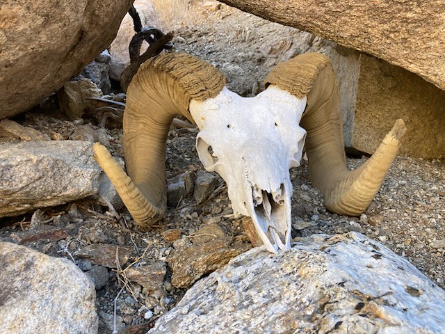
Buford wrote:
I think I know where that ram skull is. Near the bottom of a wash as an ancient trail climbs out?
Yes. Rodny posted a pic of it on an Anza Borrego Facebook group and from some of the comments it sounds like it's been there for at least 12 years and is named Herman. |
2/16/2025
Topic:
Coyote Canyon Road current conditions?
Brian
|
I've been there recently. The road is fine up until 3rd crossing, but the gate is closed there and probably will remain so for the next several years. The section between the gate and boulder alley is where the creek has taken over the road. The park would need to come up with a new route for the road in order to open it and I haven't heard any definitive word about whether they plan to do that.
So basically it's hike-only past the 3rd crossing (or bike, horse, etc) |
2/16/2025
Topic:
Coyote Canyon Road current conditions?
Brian
|
tekewin wrote:
Brian wrote:
I've been there recently. The road is fine up until 3rd crossing, but the gate is closed there and probably will remain so for the next several years. The section between the gate and boulder alley is where the creek has taken over the road. The park would need to come up with a new route for the road in order to open it and I haven't heard any definitive word about whether they plan to do that.
So basically it's hike-only past the 3rd crossing (or bike, horse, etc)
Much appreciated. Helpful...and disappointing, haha.
I know this a longshot, but is the Lower Willows Trail passable, or is that just a trail and not a road?
The closed gate is before lower willows. And in any case, Rocko and I tried to go through lower willows a couple years ago and even the foot path was badly overgrown.
I did a backpacking trip to Cougar Canyon about a month ago and the mileage wasn't too bad (about 4 miles from the gate) but it's hard to walk in the soft sand (no vehicles have been going through, so nothing to compact it).
Depending on where you're trying to go, you might be able to go down from the road that goes to Combs Peak? |
2/16/2025
Topic:
Coyote Canyon Road current conditions?
Brian
|
Also I think the upper road (from the town of Anza to Bailey's Cabin) is open. But last time I drove that it was in very rough shape. |
2/19/2025
Topic:
RHC 3 Day Backpack Trip
Brian
|
Nice overview of our trip. It was great to have some extra time to fully explore. So much to see in this area. |
2/21/2025
Topic:
Coyote south ridge
Brian
|
Great pics. I hadn't heard of that benchmark. Last year I bought a book by Robin Halford that's all benchmarks in Anza Borrego. Occasionally I do one of those hikes when I want something out of the ordinary. |
29 days ago
Topic:
RHC 3 Day Backpack Trip
Brian
|
rockhopper wrote:
I always wanted to complete the ridge trail down to Martinez along the old native trail.
That's on my bucket list too. Rocko1 and I hiked up to the ridge line from the Rockhouse Valley side a couple years ago, but we didn't continue down to Martinez. That trip would be a lot more viable for me if there was a reliable water source on the Martinez side. |
25 days ago
Topic:
Coyote Canyon Road current conditions?
Brian
|
The Lindsay book mentions there was a major grow site discovery in Alder around the year 2000. Depending on where it was, it's possible that access may have been from the top (Lost Valley Road, which goes to a PCT/Combs Peak trailhead and eventually to the boyscout camp). |
25 days ago
Topic:
Agua Alta overnight
Brian
|
rockhopper wrote:
Cactus spring trail to Agua Alta spring enjoys great views along the way. Thanks for sharing. Brings back some great memories. Been hiking that trail from below and from the top at Hwy 74 about a dozen times past 40 years. Went all the way thru from Hwy 74 to Martinez only once. Great trip report.
I have now done all of it except for a 1.5 mile section in the middle where I didn't make it all the way to Agua Alta when I came up from the bottom. The one thing that really tripped me up was a half mile section climbing out of Martinez Canyon when I came up from the bottom. It was so steep I was on my hands and knees both going up and down. And yet, according to the scanned topo layer on CalTopo (which I think is USGS), I was on the native trail.
Has this been your experience with that section? |