|
Rocko1 Posts: 615
12/18/2017
|
I have been wanting to hike from Laguna to the desert floor and interested in the best route. Other than the PCT, has anyone tried Storm Canyon or have any other routes?
|
|
|
link
|
|
dsefcik Administrator Posts: 2634
12/18/2017
|
I have not done it personally but have explored Cottonwood Cyn plenty and been to Pioneer Mail lots, you can pick a route down pretty easy. You should also be able to find a route down to Storm. Butterfield store has a book/register people have signed from coming down into Cottonwood.
--
http://www.sefcik.com
http://www.darensefcik.com
http://www.carrizogorge.com
|
|
|
+1
link
|
|
cercidium Posts: 11
12/20/2017
|
have you looked at jerry schad's book? there's a great description that takes you from mt. laguna to agua caliente—involves some stretches of bushwhacking but nothing short of rewarding. share some pics if you end up making the journey!
|
|
|
+1
link
|
|
tommy750 Posts: 1071
12/22/2017
|
Here’s my trip report on dropping down from the Lagunas via Cottonwood earlier this year: http://www.anzaborrego.net/anzaborrego/Forum/topic1279-oriflame-to-cottonwood-canyon--day-bp.aspx
You can find a way from the highway down to the top of Cottonwood Canyon looking on Google Earth. As I recall there’s different options depending on how much you enjoy brush 
|
|
|
+1
link
|
|
rockhopper Posts: 672
12/23/2017
|
I am assuming a day hike right? If so bring hiking poles, gloves ,heavy bush wacking clothes and a folding saw. btw I find it is easier going up through rough terrain than going down it. good luck and please post pics from you expedition.
|
|
|
+1
link
|
|
Scooter Posts: 114
12/23/2017
|
We did this hike last year dropped off of Monument Peak Rd. Dropped off my pack and hiking partner then parked my new truck in Mount Laguna and rode my bike back to the Monument Peak Rd turnout. Locked it to the gate. Dropped off and followed the ridge down to the desert floor. A lot of Bush whacking at first then it opens up there are cairns along the ridge top. Dropped onto the desert floor in section 5. Found a spring with good water at the end of the road in section 4. Spent the night away from the spring huge mountain lion prints by the spring !! There is a boulder the size of a house southeast of the spring that is very interesting. Hiked out the next day to Auga Caliente park and soaked in the mineral waters. Great trip not that hard.
|
|
|
+1
link
|
|
tommy750 Posts: 1071
12/26/2017
|
Rocko1 wrote:
tommy750 wrote:
Here’s my trip report on dropping down from the Lagunas via Cottonwood earlier this year: http://www.anzaborrego.net/anzaborrego/Forum/topic1279-oriflame-to-cottonwood-canyon--day-bp.aspx
You can find a way from the highway down to the top of Cottonwood Canyon looking on Google Earth. As I recall there’s different options depending on how much you enjoy brush
Great trip. Do you have any gps coordinates from this trip? Maybe entry/exit point?
If you wanted to do a straight Sunrise Hwy to S2 hike you could park at the lot .8 miles north of the northernmost intersection of Deer Park Rd and Sunrise Hwy, drop down to PCT and head south till you get to a dirt road that leads toward the top of Cottowood Canyon. It will take you to near Butterfield Ranch on S2. Am thinking they will let you park there for a fee. You can easily create your own points on GE or caltopo. Don't have clear entry/exit points since we didn't go your planned route. Hope that helps. Tom
|
|
|
+1
link
|
|
Scooter Posts: 114
11/11/2019
|
Rocko1 wrote:
I have been wanting to hike from Laguna to the desert floor and interested in the best route. Other than the PCT, has anyone tried Storm Canyon or have any other routes?
Rocko looks lime a great trip, two years ago did Schads route off the end of Monument Peak Rd down into the Potero Canyon. Spent the night at a spring on the desert floor. Next day hiked out and spent the night at Auga Caliente Springs campground. Dramatic views hiking down off the Lagunas. Good Luck
|
|
|
+1
link
|
|
tommy750 Posts: 1071
11/11/2019
|
Rocko1 wrote:
Will be getting some time off soon and I'd like to try this route https://caltopo.com/m/S0R8 as a day hike. The majority of it appears to be on BLM. Anyone see any issues with this and the possibility of it crossing private land?
Can't comment on the Cuyamaca route but your Mason Valley truck trail and Cottonwood routes look fine. You could take a bit of the old Lassater Hay road back to your vehicle by following a ridge with a faint road just as the MVTT turns toward the NW. Pull up the 1915-1945 historic topo layer to see it.
|
|
|
+1
link
|
|
deborah Posts: 115
11/13/2019
|
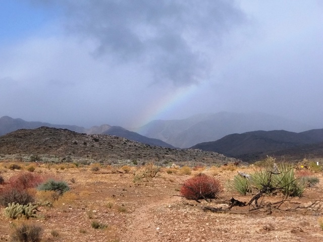
These routes look like fun. I did the Mason Valley Truck Trail from Blair Valley a few years ago. It was really pretty, only saw two vehicles despite it being on the weekend. I especially like the change in vegetation along the route. And it was a little drizzly that day too. Started off the day with a nice rainbow!
Whichever route you choose, looking forward to hearing how it goes!
|
|
|
+1
link
|