4/20/2010
Topic:
Hiking to Goat Canyon Trestle
dsefcikAdministrator
|
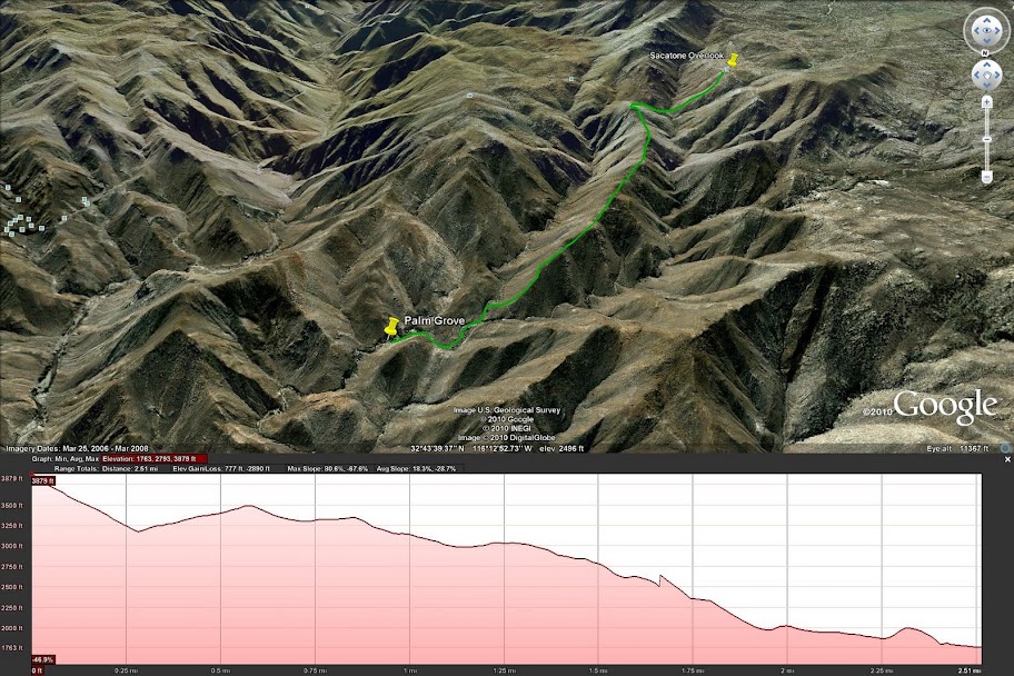
We tried to get to the trestle and were very close. We started at Sacatone Overlook, see details of the trip here:
http://www.sefcik.com/index.php/2010/04/19/sacatone-overlook-to-goat-canyon-hike

Daren
<em>edited by dsefcik on 4/21/2010</em> |
4/21/2010
Topic:
Hiking to Goat Canyon Trestle
dsefcikAdministrator
|
hikerdmb wrote:
Daren,
That looks like a long and rugged hike through some pretty incredible terrain. However when I click on your link I get a blank page. Can you check that? I would like to see more details about this trip.
David
Maybe I just messed up the url tag, I edited it and seems to work now. If not just copy/paste this url into your browser
http://www.sefcik.com/index.php/2010/04/19/sacatone-overlook-to-goat-canyon-hike |
4/22/2010
Topic:
Hiking to Goat Canyon Trestle
dsefcikAdministrator
|
hikerdmb wrote:
Daren,
It worked for me too. NIce trip. I left you a comment on the site.
David
Thanks, I replied back..
There are so many possible hiking routes out there. I will put together a few more and post them to see if there is any interest.
Daren |
4/22/2010
Topic:
Hiking to Goat Canyon Trestle
dsefcikAdministrator
|
surfponto wrote:
Hey Daren,
The link works for me.
Those rattlesnake pictures are great!
Looks like you were pretty close unless you had a good zoom lens 
I actually just got back from Dos Cabezas. I had planned to solo hike from Mortero Palms to the Trestle but the weather kind of messsed up my plans.
When I opened the door of my landCruiser the wind almost blew it off.... :-0
There were also the occasional rain squalls blowing over the mountains so I decided to leave it for another day.
Bob
I was within a few feet of both them but I ran as soon as I heard them rattle. Scott stepped up and took the pictures, he had a zoom camera and stayed a good 15' feet or so back. The canyon that leads up to the trestle has a very steep rock face at the bottom, almost dry fall'ish like. You can see it in Google Earth, barely. There is another way or two up from the gorge. I will draw up a few maps and post them to see if anybody is interested in trying them.
Daren |
4/23/2010
Topic:
Hiking to Goat Canyon Trestle
dsefcikAdministrator
|
So just from the last 4 times I hiked this similar route I think this is doable given:
1. You are willing to hike some portion on the tracks
2. You will be hiking all day
3. It wont be easy, there are no trails other than animal paths and maybe my footprints from a couple of weeks ago
4. If you drive from San Diego you save lots of driving time by getting off at Boulevard instead of heading out to the S2
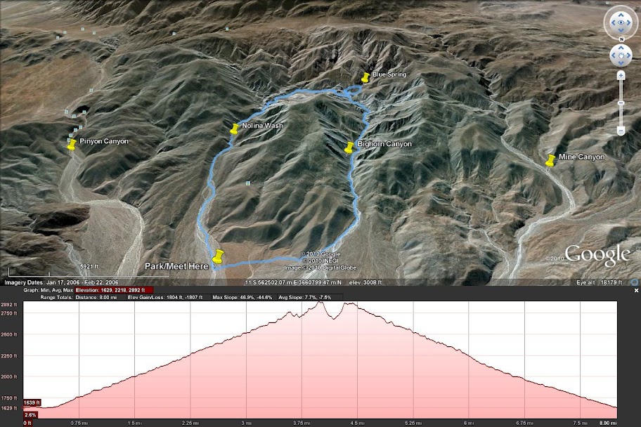
You can see from image #2 that from Mortero Palms this route is not the shortest.
I can post a Garmin gdb,generic gpx or google earth kmz if you want..in fact I wouldn't mind trying this route. If you go and want company let me know.
Daren

 |
4/24/2010
Topic:
Hiking to Goat Canyon Trestle
dsefcikAdministrator
|
surfponto wrote:
That is awesome.
Really puts the whole thing in perspective. Not sure my wife would want to do the hike from Sacatone overlook.
I convinced her we can do it from the South end of Carrizo Gorge and I am anticipating about 3 miles one way from where we park.
I am going to do a better job setting waypoints this time since on our last attempt a couple years ago we got a bit lost.
Carrizo Gorge To Goat Canyon
We are thinking leaving early Thursday if nothing comes up at work before then. You are welcome to join us.
edited by surfponto on 4/24/2010
I would love to go but need to see what happens Tuesday first, I would need to be back in Point Loma by 5pm.
Do you have a route of where you plan to hike thru the gorge? I will say that the canyon up to the trestle will be tough, at least the first part as it looks like a steep dry fall or cliff at the beginning. The ridge to north may be the best way, that is what stonewell's group did. In fact if you read the post you will see they ascended the utility road just south of where my map shows going up the ridge. They then walked the tracks thru the long tunnel and then the short tunnel to get the trestle. My map takes the utility rd around the long tunnel.
See the maps below for what I am talking about.

 |
4/24/2010
Topic:
Hiking to Goat Canyon Trestle
dsefcikAdministrator
|
surfponto wrote:
Meant to ask. Is that the standard Google earth you are using? It looks better than mine
Google Earth
5.1.3509.4636 (beta)
Build Date
Sep 17, 2009
Build Time
3:18:34 pm
Renderer
OpenGL
Operating System
Linux (2.6.31.0)
Video Driver
ATI Technologies Inc.
Max Texture Size
8192x8192
Server
kh.google.com |
4/24/2010
Topic:
Hiking to Goat Canyon Trestle
dsefcikAdministrator
|
surfponto wrote:
I honestly don't know how much time to allow for this?
Bob
We were moving about .5-.75mph thru the gorge, it was slow moving. Once you start the climb up to the trestle it will be even slower. We just had a hard time picking a route, there was so much brush and rock. I don't know what the gorge looks like north of Goat Canyon so you can make a determination based on your last trip I am sure.
Daren |
4/24/2010
Topic:
Hiking to Goat Canyon Trestle
dsefcikAdministrator
|
surfponto wrote:
That is awesome.
I convinced her we can do it from the North end of Carrizo Gorge and I am anticipating about 3 miles one way from where we park.
edited by surfponto on 4/24/2010
Do you mean the "north" end? If the south, where are you parking?
<em>edited by surfponto on 4/24/2010</em> |
5/3/2010
Topic:
Carrizo Gorge East Fork to Carrizo Palms
dsefcikAdministrator
|
I went with Bob and have some pics also, probably very similar. Very nice day out in the back country with you and your wife, I had a good time.
http://www.sefcik.com/index.php/photo-gallery/carrizo-gorge-to-goat-canyon-trestle-05-01-2010/
Daren
surfponto wrote:
Hey David,
That was the hike we did last year.
My friends liked it , but underestimated the amount of water they needed :-)
We ended up hiking to Goat Canyon yesterday. Haven't written the post but here are the pics.
Goat Canyon Hike
regards,
Bob
hikerdmb wrote:
Bob,
Nice hike. Looks warm. I take it you did this hike instead of the hike to the trestle you had mentioned for last Thursday. It looked REALLY windy on Thursday last week, 40+ gusts. How did the "newbies" like the desert? And did you really say last trip of the season?
David |
5/3/2010
Topic:
Peak 6582
dsefcikAdministrator
|
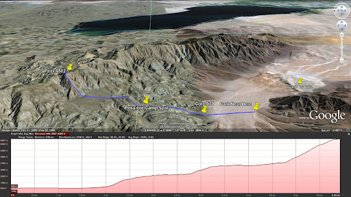
I have a gps track planned out for peak 6582 based on Jerry Schads book. See Google Earth image below.
This could be a 2 day backpack or a very long single day trip. Anybody interested in trying this out?
Daren
<em>edited by dsefcik on 11/9/2010</em> |
5/3/2010
Topic:
Peak 6582
dsefcikAdministrator
|
Jerry Schad's book lists it as 12 miles with a 5 star rating, the highest given in his book. You will ascend 3,000' feet in 1 mile from the bottom of the peak to the top. That also means a descent of 3,000'. There was snow up there during spring break..so at almost 7,000' it can be cold.
My personal take is one of the following:
1. Drive out to the start point and camp over night, leave early in the morning and hike it all in one day, camp the night again at the parking spot and drive home on the 3rd day.
2. Drive out, hike to a camp spot in one day, hike the peak the second day, return to parking spot and drive home late(this is what Jerry recommends).
3. #2 but camp overnight at the parking spot and drive home the 3rd day.
I kinda like #1 and you can carry water out to the half way point and refill on the way back. This also provides some comfort of a base camp with "all the amenities". Depends on your perspective I suppose.
Daren
surfponto wrote:
Hey Daren,
I would be interested.
What is the distance on that?
Bob |
5/3/2010
Topic:
Peak 6582
dsefcikAdministrator
|
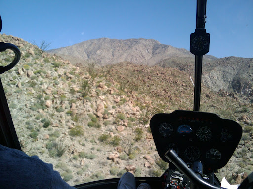
I should probably also add that from the helicopter tour of Anza Borrego it looked pretty rugged.
Here is a pic coming up out of the dry lake area and looking towards the peak:
edited by dsefcik on 5/3/2010
<em>edited by dsefcik on 11/9/2010</em> |
5/4/2010
Topic:
Hiking to Goat Canyon Trestle
dsefcikAdministrator
|
I would like to see more pics of the truck, thanks..
surfponto wrote:
Here are the pics I have so far.
Goat Canyon Trestle Hike Photos
I have a couple more truck ones I can send you also.
Bob |
5/4/2010
Topic:
Hiking to Goat Canyon Trestle
dsefcikAdministrator
|
I have a few also, probably similar to yours:
http://www.sefcik.com/index.php/photo-gallery/carrizo-gorge-to-goat-canyon-trestle-05-01-2010/
Daren
surfponto wrote:
Here are the pics I have so far.
Goat Canyon Trestle Hike Photos
Bob |
5/4/2010
Topic:
Carrizo Gorge East Fork to Carrizo Palms
dsefcikAdministrator
|
hikerdmb wrote:
Daren,
In pic 28 is that a rail car coming up the tracks? It looks like the lights are on. Did they stop you for being on the tracks? That looks like a great hike. Getting your Dodge up that trail must have been pretty tight in some spots. I love the view looking down from the trestle.
David
Ah..yes...pic #28...I actually did not mean to include that one...
http://www.cgrp.us
psych....
Lets just say we saw some adventurous souls out there on the tracks and they were not on mountain bikes. Never did see who they really were, that was the only picture I was able to get before they were gone.
The Dodge made it no problem but it did suffer a lot of scratches from the brush, in fact my son made a remark when I got home that I ruined the paint on my new truck. I'll take it again, that's what I bought it for.
I was just thinking today I would like to go out again and spend the day exploring the rock caves..anybody interested?
Daren |
5/4/2010
Topic:
Carrizo Gorge East Fork to Carrizo Palms
dsefcikAdministrator
|
surfponto wrote:
I have been looking at the Google Maps and I see a good route up through the East Fork to the tracks also. :-)
Maybe for another time
I saw that also, my #2 route from Sacatone is also a good route I believe and saves tons of driving time.
surfponto wrote:
Slide Show Version link
Works better in Internet Explorer but I am working on fixing it.
Doesn't work on Linux with Chrome..8-> |
5/7/2010
Topic:
Peak 6582
dsefcikAdministrator
|
How about May 21,22 & 23rd? |
5/7/2010
Topic:
Carrizo Gorge East Fork to Carrizo Palms
dsefcikAdministrator
|
The 15th or 16th? I can do that..let me know.
surfponto wrote:
I would like to spend some time in there exploring the rock caves in Carrizo Gorge
I think there is alot of stuff to see.
I would also like to hike up to that Palm Grove off to the right that we saw from ontop of the tracks.
This weekend isn't looking good but maybe next weekend.
Bob
dsefcik wrote:
hikerdmb wrote:
Daren,
In pic 28 is that a rail car coming up the tracks? It looks like the lights are on. Did they stop you for being on the tracks? That looks like a great hike. Getting your Dodge up that trail must have been pretty tight in some spots. I love the view looking down from the trestle.
David
Ah..yes...pic #28...I actually did not mean to include that one...
http://www.cgrp.us
psych....
Lets just say we saw some adventurous souls out there on the tracks and they were not on mountain bikes. Never did see who they really were, that was the only picture I was able to get before they were gone.
The Dodge made it no problem but it did suffer a lot of scratches from the brush, in fact my son made a remark when I got home that I ruined the paint on my new truck. I'll take it again, that's what I bought it for.
I was just thinking today I would like to go out again and spend the day exploring the rock caves..anybody interested?
Daren |
6/7/2010
Topic:
First fumbling pass at experiencing Anza Borrego
dsefcikAdministrator
|
That was a great writeup, I enjoyed reading it. If you do decide to visit in the 110+ heat, make sure your car can also handle it. When the desert heats up most people stay away. I have been out there on those days and in places where there would normally be crowds it is completely empty. Don't forget water, lots of it! |
6/7/2010
Topic:
First fumbling pass at experiencing Anza Borrego
dsefcikAdministrator
|
Reading your post made my day, it was very entertaining..I like your writing. Sorry to hear about the bum disc, hope you recover well.
I will say though..you have the coolest name ever!
Daren
quidditian wrote:
Thanks Daren! I'm glad you endured/appreciated the rambling. :]
I've been out of pocket the last couple of months...finally had an MRI on Friday, and results came in today that I have a large herniated disc. I've been walking at a 90 degree angle for the last two months (pretty pretty), so glad to finally identify the problem. But alas, I'm ****ed I've been locked up inside for a couple of the prettiest months of the year...even my easel has sat barren, collecting cobwebs (an appropriate metaphor for my decrepit state of decay). Probably could have made one more foray out to the desert since it's been relatively temperate this year, but now I'm definitely not going to be making any adventures out there until the weather is less evil...and when I'm not walking like Australopithecus.
I know, I know. I'm a little ray of sunshine.
I need to get updated on y'alls recent posts -- it'll give me inspiration to become mobile again.
To your point, Daren -- when I do go back, I doubt I'll take my silly little car...it's vehicularly debilitating...my sis has said I can borrow her big 'ol honkin' truck for the next trip. Or maybe I'll get something like this...
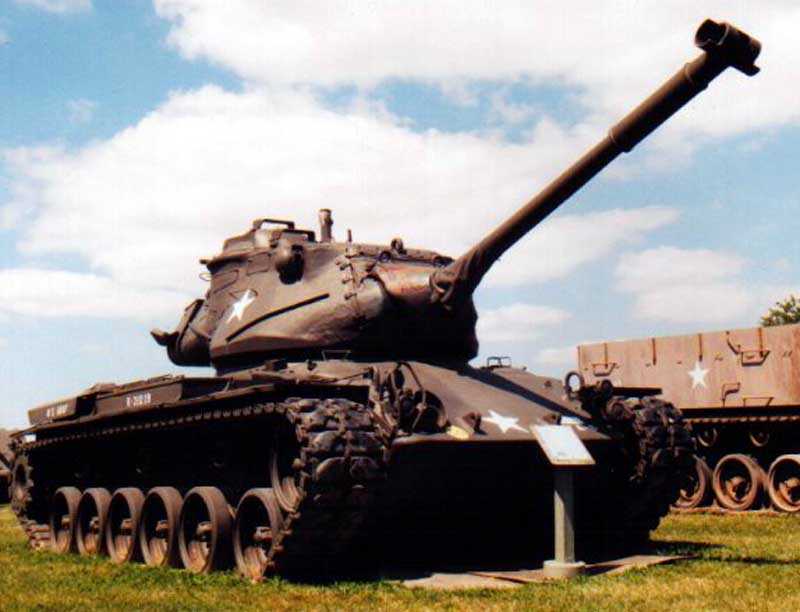
Or, in case embedding the pic didn't work (since I'm technologically challenged): http://www.richard-seaman.com/Aircraft/Museums/Kenosha/Tanks/Tank.jpg
<em>edited by surfponto on 6/15/2010</em> |
6/19/2010
Topic:
Sombrero Peak via McCain Valley
dsefcikAdministrator
|
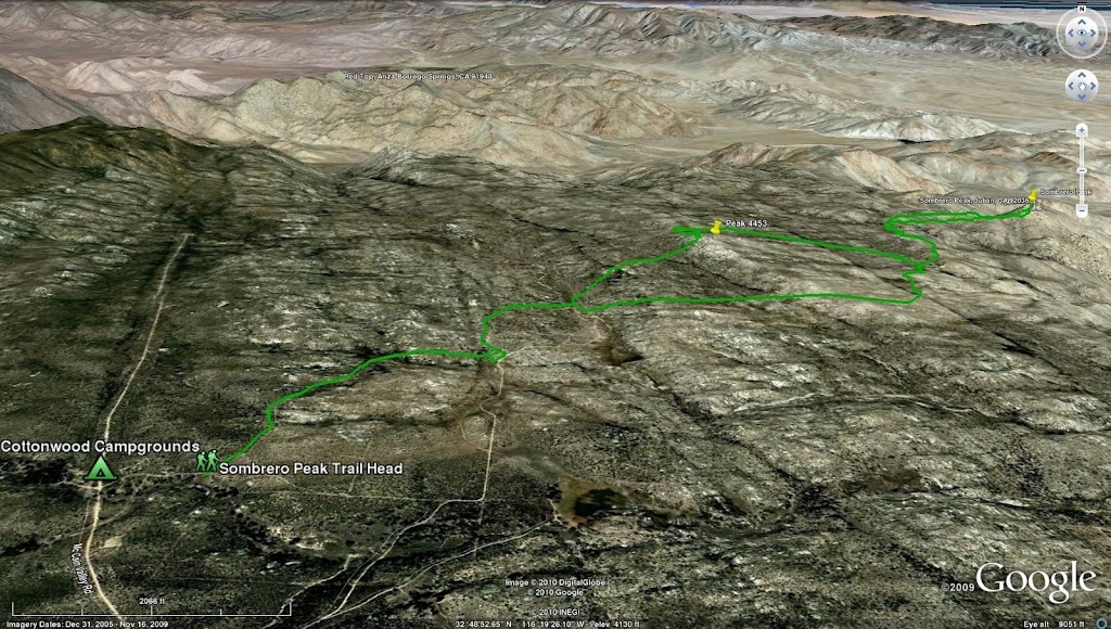
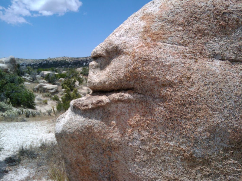
I hiked out with a friend of mine on 6-12-2010 to Sombrero Peak via McCain Valley. It was a great hike, perfect weather and not a soul in sight. I really liked this trip as it saved a few hours of driving by starting in McCain valley instead of dropping down into the desert floor. We camped out overnight and explored the Sawtooth Mtn range the following day. A complete report can be read on my website with more pictures.
http://www.sefcik.com/2010/06/sombrero-peak-via-mccain-valley-hike.html
The trip from Google Earth
An interesting rock face along the trail
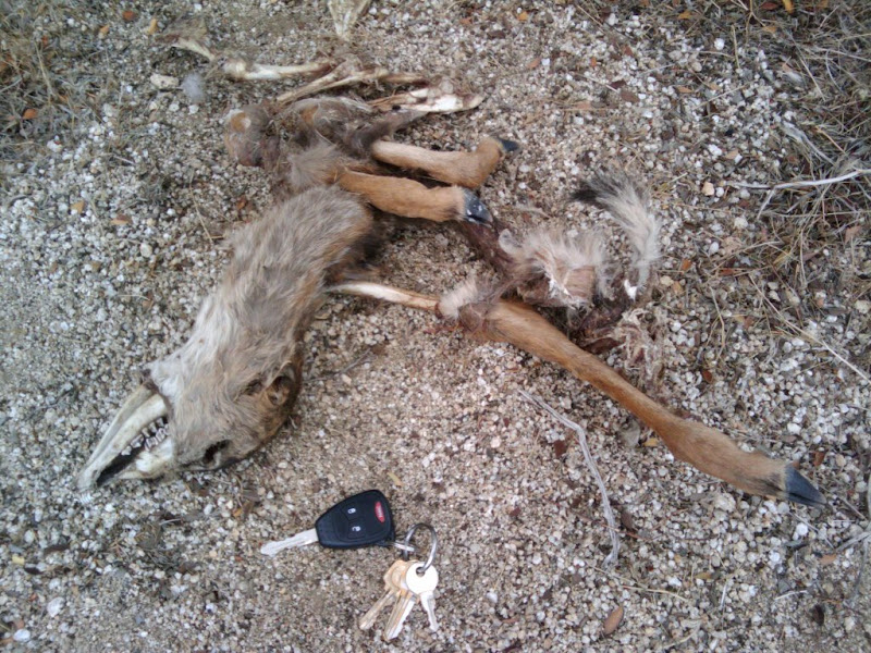
Young deer we found at the bottom of peak 4553
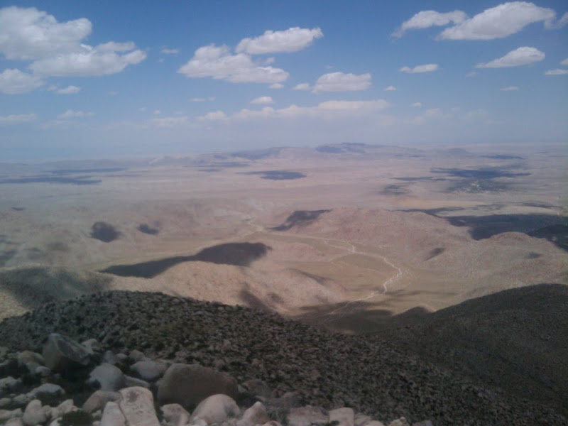
View of Anza Borrego from the top of Sombrero Peak
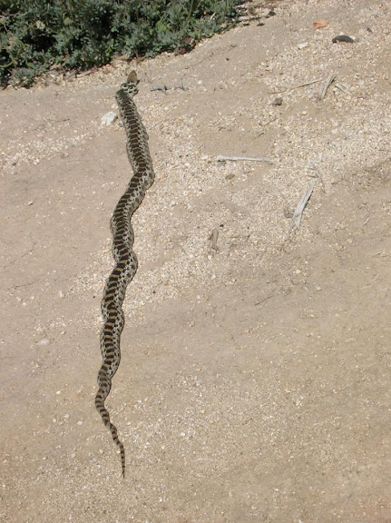
Anybody know what kind of snake this is? California glossy snake??
Daren
edited by dsefcik on 6/19/2010
edited by dsefcik on 6/19/2010
edited by dsefcik on 9/28/2010
edited by dsefcik on 9/28/2010
<em>edited by dsefcik on 9/28/2010</em> |
6/22/2010
Topic:
Indian Hill 06-21-2010 Trip Report
dsefcikAdministrator
|
Full trip report with pictures here: http://www.sefcik.com/2010/06/indian-hill-06-21-2010.html

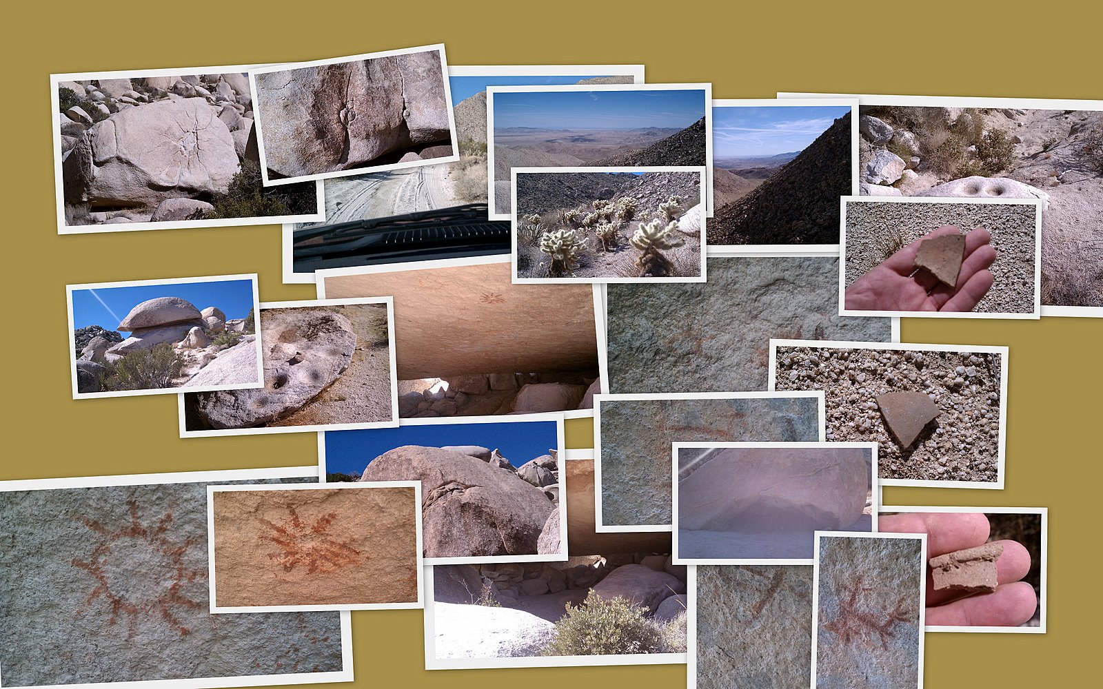
I had heard about some rock art that was out near Indian Hill so I decided to try and find it. I will admit I did not do much homework before I left, I just saw Indian Hill on my topo map and figured I would find it if I hiked around enough. I had expected and prepared for triple digit temperatures, packing 6 liters of water and some salty snacks in my pack. I also expected and planned for rattlesnakes, bringing my new hiking stick and careful walking technique. I have seen snakes every trip out this season and expected the same for this trip.
I have never been out to Indian Hill or the Dos Cabezas area so I used a Jerry Schads guide to follow the road out. It was bumpy but easy in my 4×4 truck. There was one section right after Dos Cabezas siding that looked as though it suffered from the recent rains, I don’t think a passenger car would have made it past that point.

I got a late start being Monday and all, I worked thru the morning and then headed out around noon and arrived at the end of Dos Cabezas around 1:30. The temps were in the low to mid 90′s and I don’t think it ever got above 95 degrees so it was a mild day for me. I hiked out thru the alluvial wash towards Indian Hill.
Not sure where the pictographs were exactly I started looking at every hill out there. After 3 hours and lots of boulder climbing I realized I was not going to find any rock art. The whole time I was thinking why would anyone now or 6000 years ago climb way up these boulders to draw on rocks..?? I knew I was looking in the wrong place. It was getting late and I decided instead to focus on all of the other really cool things about being in the desert, the beautiful landscape, the solitude, the catclaw stuck in my legs….
It was getting late, almost 5pm and I figured it was time to start heading back to make sure I got out of there before dark and have some spare time just in case I had a flat or some other emergency. When I explore alone out in the back country I tend to be over cautious. I figure I would swing around one last clump of boulders and beeline straight back to the truck. I found a pretty cool cave and then saw some morteros. I thought maybe I was close…

Some of the morteros showed obvious signs of indian occupation and there were lots of Yoni carvings. I kept looking around but did not find the pictographs, they alluded me this visit. I needed to head back to the truck by this point as it was 5:30 and I still had a good 45 minute walk to the truck and another 45 minutes or so of driving dirt road to get to the highway.
When I got home I did more research on the rock art and after looking at several photographs from other sites I realized I was right on it but somehow missed it. I will definitly go back out and spend more time looking not just for the cave but also at all of the other incredible things in that area of the desert.

A few of things for this trip out, I did not see anyone else out there except for a lone border patrol officer exiting the dirt road when I arrived. The (2) water containers I looked in were empty and looked run down, like they had not been restocked in some time. No rattlesnakes..wow! I guess during the heat of the day they take shelter in whatever shade they can find. I did see signs of illegals travleing thru the area, faded water jugs, food cans, faded clothing, etc. I saw very little signs of animal scat except near the “really nice cave” where there were heavy concentrations of cat scat. I saw at least 10 large jack rabbits and the washes were full of rabbit and other small animal tracks. I did not see large animal tracks though, just a few small deer tracks.
<em>edited by dsefcik on 9/28/2010</em> |
6/29/2010
Topic:
Indian Hill 06-21-2010 Trip Report
dsefcikAdministrator
|
Just an update, I went back out yesterday (Monday the 28th) and found the cave and more morteros and Yoni carvings. The cave is tricky to find even after looking at all of the pictures on the Internet. With temps around 105 degrees during the day the cave was remarkably cool and breezy, that was the best spot to be in all day. The paintings are faded but still visible, I think even more interesting is all of the Yoni carvings, they are everywhere once you realize what you are looking at. Jack rabbits and all kinds of lizards were out, still no rattlesnakes though. Again, I was the only sole out there.
Daren
 |
6/29/2010
Topic:
Sombrero Peak via McCain Valley
dsefcikAdministrator
|
I think the total was around 10-11 miles. I would consider it an easy hike, mostly sandy trail with some boulder climbing to get up to the peak but not much. It took us around 7 hours total and we explored around a bit, no hurry at all. All of the boulders out there are really cool!
surfponto wrote:
Hey Daren,
What is the distance on that hike?
From the Google Earth shot it looks far :-)
Bob |
9/2/2010
Topic:
It's time
dsefcikAdministrator
|
I have never been out to Whale Peak, that looks like a great place.
I really want to backpack the entire Carrizo Gorge and also out to peak 6582. I am thinking some time between now and Thanksgiving. Anybody else interested?
I just got back from a 9 day trip in Death Valley, hiked around and saw lots of really cool stuff, avg temps were around 120 most of the time.
Daren |
9/4/2010
Topic:
It's time
dsefcikAdministrator
|
As your picture shows, the Hantivirus warnings in all the cabins make me shy away from them. I generally sleep in the back of my truck or outside. I just finished going thru my pictures and posted some here:
http://picasaweb.google.com/daren.sefcik/DeathValley82010?feat=directlink
It was a great time and the average daily temp was 120. Living out of the back of my truck for 8 days in that heat with 14 hour days was definitely a challenge. If we ever hook up in person we can chat about our adventures out there.
As for Carizzo Gorge, I am ready, I just bought a new 24" stainless steel machete. The only trails I have seen out there are animal trails, deer,cat,coyote,etc..It can be done I don't think the illegals go down the gorge much, I think they stay on the train tracks. I am thinking sometime around thanksgiving. If you are interested PM me, I *may* have another taker as well and we will see if Bob wants to go.
Daren
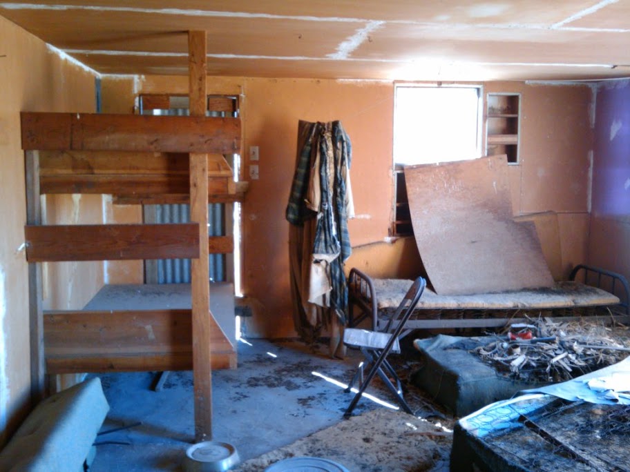
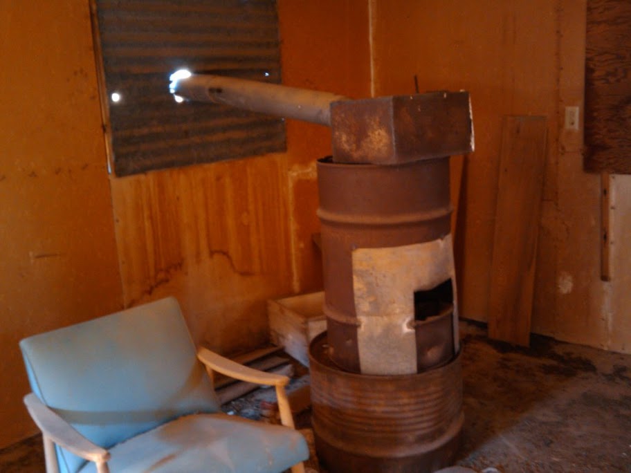
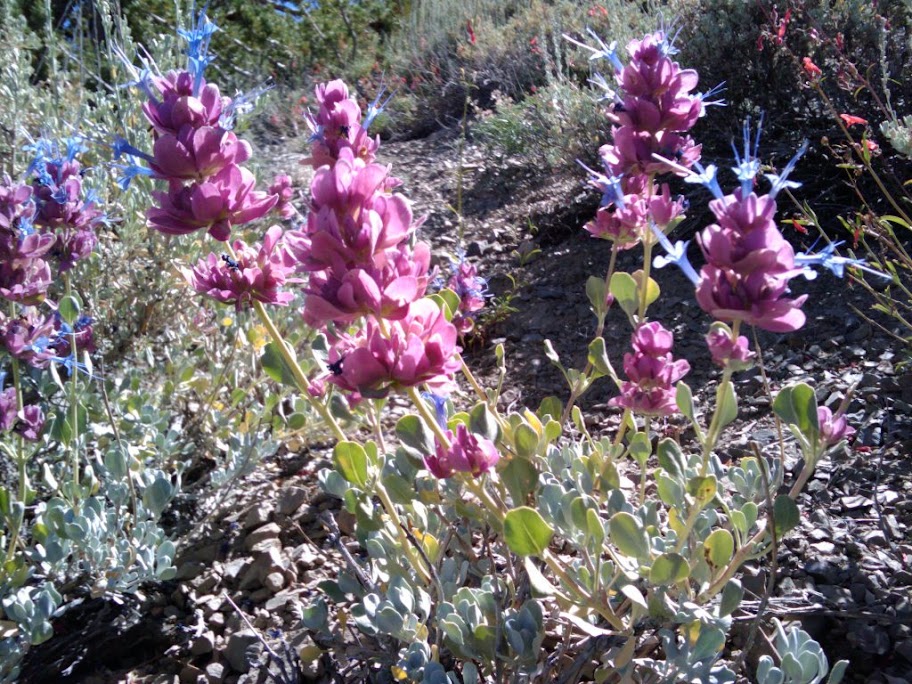
Greene-Denner_Drake Mill Cabin
Flowers on Telescope Peak Trail
<em>edited by dsefcik on 9/4/2010</em> |
9/22/2010
Topic:
It's time
dsefcikAdministrator
|
surfponto wrote:
9 days in Death Valley! You are hardcore :-)
Sounds like a great trip.
Did your son go with you?
Bob
I wrote it up here: http://www.sefcik.com/2010/09/death-valley-trip-august-2010.html
My son did not go..8-(
Bob, you up for a Peak 6582 or Carrizo Gorge hike?
-- |
9/22/2010
Topic:
It's time
dsefcikAdministrator
|
From the CDC website:
Hantavirus pulmonary syndrome (HPS) is a deadly disease from rodents. Humans can contract the disease when they come into contact with infected rodents or their urine and droppings. HPS was first recognized in 1993 and has since been identified throughout the United States. Although rare, HPS is potentially deadly. Rodent control in and around the home remains the primary strategy for preventing hantavirus infection.
Most of the back country cabins have substantial rodent problems and there are numerous warnings in them about Hantavirus.
I am wondering if you and Mary might be interested in some kind of hike down the entire Carrizo Gorge canyon and we can arrange to have vehicles down at the end for a Thanksgiving camp out. Maybe have some friends who do not want to hike meet us there or??
Just an idea, I would be totally up for something like that. The Carrizo Gorge hike would be a 2 or maybe 3 day hike down from the freeway.
Daren
surfponto wrote:
Hey Guys,
We actually may be out there on Thanksgiving. Usually it is a family thing so I am not sure I could get everyone to do the hike.
Mary and I could always hang out another day and do it.
I really like those cabin pictures you both put up. That is pretty amazing.
What is this Hantvirus you are talking about?
Bob |
9/22/2010
Topic:
It's time
dsefcikAdministrator
|
hikerdmb wrote:
I had last weekend free and it was too hot in the desert for me, I can't do that hot hiking like Daren, so I left after school on Friday and headed to Independence. Dayhiked up Kearsarge Pass with my dog on Saturday. Did a short detour on the way down to visit a couple other lakes. Then drove back home on Sunday.
I don't have a date yet picked out for Whale Peak but I will let you know when I plan to do it. I am not sure of the Carrizo hike either. When you pick a date let me know and hopefully I can make that. That should be an adventure.
Here is a pic from the trip to the Sierra last weekend. It was beautiful except there is a fire over by Cedar Grove that made it pretty smoky in the afternoon and evening.
David
That looks like a great time, right near treeline...ahhh, nice and cool....
Anza is still showing temps in the triple digits, it has been consistently hot this year. To realistically hike the gorge it should be done in cooler temps that is why I am thinking November. |
9/27/2010
Topic:
Old Cabins in Aznza Borrego
dsefcikAdministrator
|
I know Death Valley has a lot of old mining cabins to explore and even stay the night in, I was wondering if there are any cabins in Anza Borrego? |
9/27/2010
Topic:
Old Cabins in Aznza Borrego
dsefcikAdministrator
|
David, thanks for the pics and info, I appreciate you taking time to post all of that. I was actually thinking of hiking out to the rockhouse ruins this weekend or the next. I also saw the Baily cabin mentioned in my AB book but it did not say much about it. I guess ABDSP does not really have much for mining cabins like DV.
Do you know how bad the road is past the Alcoholic Pass trial going up to rockhouse canyon? General consensus from books I have are that after 8-9 miles it may not be drivable. I have a big diesel 4wd truck but deep,deep sand may not be it's best friend. If not drivable than that adds another 4 miles each way up rockhouse canyon which is significant.
thanks! |
9/28/2010
Topic:
Old Cabins in Aznza Borrego
dsefcikAdministrator
|
hikerdmb wrote:
Sorry about that previous response but I was thinking I read you were going to Bailey Cabin since Alcoholic Pass goes from Coyote Canyon too. But the road to Rockhouse Canyon is different. It is not too bad until you get to the junction where Rockhouse goes to the right and I think it is Butler Canyon to the left. From that point on it is very rocky and slow going but no big hills or real narrow parts to get through. Lots of small round rocks to crawl over but nothing big. Your truck should make it up. The road actually ends about 50 yards or so from Hidden Spring (I think that is the name). I have not been up that far in a few years but I just remember it being slow and rockyn the last 3 or 4 miles but not dangerous. Hope this helps.
David
Yes, this is exactly where I was referring to...thanks! I had read it had very deep sand after about 9 miles. I think I can deal with rocks, especially if it will save 8 miles of hiking. |
10/7/2010
Topic:
Sacatone to Palm Grove
dsefcikAdministrator
|
A friend of mine are tentativly planning a hike from Sacatone Overlook to Palm Grove this coming Sunday (10-10-2010). See the map below for a general idea of where we will be hiking. If you are interested in going let me know.
Thanks,
Daren
-- |
10/8/2010
Topic:
It's time
dsefcikAdministrator
|
I think 2 long days..yes..
Ideally someone would drop us off so we don't have to go back and pick up a vehicle.
Maybe PM me so we can discuss options offline.
Daren
surfponto wrote:
That sounds like it may work.
We are planning on meeting friends at the start of RH Canyon on Thanksgiving Day.
We would have to leave our Landcruiser there and then maybe hike in from the 8
I am thinking we could do it in 2 days?
dsefcik wrote:
From the CDC website:
Hantavirus pulmonary syndrome (HPS) is a deadly disease from rodents. Humans can contract the disease when they come into contact with infected rodents or their urine and droppings. HPS was first recognized in 1993 and has since been identified throughout the United States. Although rare, HPS is potentially deadly. Rodent control in and around the home remains the primary strategy for preventing hantavirus infection.
Most of the back country cabins have substantial rodent problems and there are numerous warnings in them about Hantavirus.
I am wondering if you and Mary might be interested in some kind of hike down the entire Carrizo Gorge canyon and we can arrange to have vehicles down at the end for a Thanksgiving camp out. Maybe have some friends who do not want to hike meet us there or??
Just an idea, I would be totally up for something like that. The Carrizo Gorge hike would be a 2 or maybe 3 day hike down from the freeway.
Daren
surfponto wrote:
Hey Guys,
We actually may be out there on Thanksgiving. Usually it is a family thing so I am not sure I could get everyone to do the hike.
Mary and I could always hang out another day and do it.
I really like those cabin pictures you both put up. That is pretty amazing.
What is this Hantvirus you are talking about?
Bob |
10/11/2010
Topic:
Sacatone to Palm Grove
dsefcikAdministrator
|
This trip was a bust..my usually dependable friend bailed out at the last minute..crying about something like it was gonna be too hot...sigh...I ended up just going for a 15 mile run around the lake near my house and drank some beer instead.
Daren |
10/11/2010
Topic:
Whale Peak Backpack Possibility
dsefcikAdministrator
|
I want to go for an overnight backpack trip this weekend and have a few possibilities, one being Whale Peak. I know there are a couple of informal trails up the peak but I mapped out something in google earth, does this look realistic to anyone?
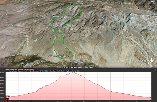
It looks like about 11 miles total distance and about 1,000' per mile up and down, not too bad IMO. I am just not sure of the actual terrain. Basically it would loop up the south side starting in Bisnaga Alta Wash, camp at Whale Peak and then down thru Smuggler Canyon with a stop at the petroglyph's the next morning.
Anybody interested in trying this?
Daren
<em>edited by dsefcik on 10/11/2010</em> |
10/12/2010
Topic:
Sacatone to Palm Grove
dsefcikAdministrator
|
Cayenne..your killing me with your stories..do you write any books? I would probably buy one if so.
As for the "reality" shows I have always thought unless the person is recording everything with a head cam or something it could not be that hard or wild if a camera crew is following them around, especially when they have to go first to a good front shot of the action.
Keep up the comments/writing, I love it.
Daren
quidditian wrote:
Heehee -- You guys are like, Desert Militia -- on my best day, I wouldn't be able to keep up with any of you guys even if you were in full body casts. I need somebody wussy to join this board so we can take little day trips where we tip-toe through the tulips and whine at the first sign of a bead of sweat. I wonder if Paris Hilton or David Sedaris would be interested in being my winter hiking buddy.
On a side note, when I took my car to get smogged, I noticed something hanging down from the undercarriage of my car. I asked the guy whether it was anything scary, and he said it was just a piece of plastic that had ripped down, but nothing that was an issue to the operation of the car. I felt all butch and grizzled as I said "ah, must've happened out in the desert" -- like I was Steve Friggin' Irwin or something.
On another side note, I broke down and got cable a couple of months ago, b/c I was trapped in bed so much with my herniated disc, and my new favorite show is "Dual Survival" -- I'm preaching far and wide that people should watch it, even if they don't have any plans of getting stranded in the Peruvian desert or a Louisiana swamp -- it's just really fabulous info/entertainment for anyone even vaguely interested in nature - whether or not they're "outdoorsey." I think it's far superior to the one "Man vs. Nature" episode I caught -- though maybe I just caught it on a bad day.
It's on Discovery, so y'all should give it a try if you happen to run across it one night.
The full back episodes are available for viewing here:
http://dsc.discovery.com/tv/dual-survival/episodes/
(update: I just tried to go watch a couple I've missed, and the vids are "currently" down -- and I'm not sure they're still the full vids anymore, even when working -- when I sent the link to someone a couple of weeks ago, the vids were working AND it was for the full 45ish minutes of the show)...
That said, it might be annoying for ppl who are truly hard-core outdoorsmen...the situations in the show are admittedly contrived, but judging by a lot of press I've seen recently, most nature shows (or situations therein) are at least partially contrived -- gotta keep it exciting of teevee, after all.
Cayenne
edited by quidditian on 10/12/2010 |
10/14/2010
Topic:
New Premier issue of Dezert Magazine launched
dsefcikAdministrator
|
Cool!! |
10/14/2010
Topic:
New Premier issue of Dezert Magazine launched
dsefcikAdministrator
|
There is no way to buy the magazine or contact anyone. Can you pass that comment on to him? Also, if he has plans to reprint past issues or at a minimum provide or sell PDF versions.
The In-Ko-Pah article is a great one, I remember reading that on the Internet awhile back. |
10/14/2010
Topic:
New Premier issue of Dezert Magazine launched
dsefcikAdministrator
|
Just figured out how to print to a PDF, very nice. |
10/24/2010
Topic:
After an autumn rain
dsefcikAdministrator
|
Those are some really nice pictures, thanks for the report!
I have also gone out the last two weekends and it has been really beautiful. I have not had time time write anything up but pictures are here:
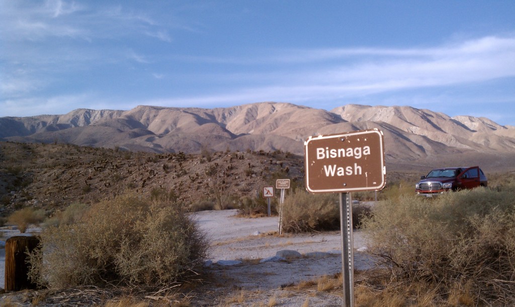
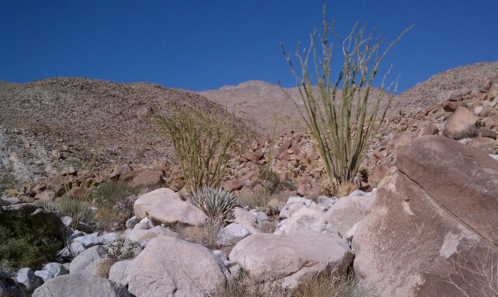
Bisnaga Wash
Inner Pasture
--
<em>edited by dsefcik on 10/24/2010</em> |
10/24/2010
Topic:
After an autumn rain
dsefcikAdministrator
|
Do you have a link to a better, more close up pic of the animal tracks? |
10/25/2010
Topic:
After an autumn rain
dsefcikAdministrator
|
Those are some great track photos!
Kit fox prints are about 1.5", 4 paw and have signs of claws when quickly walking or running so that could be. The second one looks like some kind of lizard or other tail dragging critter. I have not seen one like that before, I am gonna try to research it some more.
Here is a similar looking track from Death Valley I found:
.jpg)
Bisnaga Wash was my re-con mission to check out the Whale Peak hike. Yes, it can be done, it will be steep and rocky though the last 2 miles (as seen in my pictures). In fact, I dare say the whole hike could be done in a single day with cool weather. I have that on my itinerary.
Inner Pasture was supposed to be a backpack trip with a climb up Red Top but the night before I had some other things happen that prevented me from doing that and I went for a quick day hike instead. The entire route I traveled was about 8.5 miles and I did it in 3.5 hours with a 50lb backpack on (for training). So you should be able to make a nice full day hike out of it if you wanted and possibly cover more ground than I did. There is supposed to be numerous areas around there that have signs of indian occupation. I saw (4) sets of prints from illegals all coming out of the wash, all the same shoe print, (3) walking closely together and the fourth always off to the side..kinda interesting. I really did not think illegals would be out there but all of the discarded water bottles, clothing and such seem to indicate it is a popular area for them.
Daren
--
<em>edited by dsefcik on 10/25/2010</em> |
11/1/2010
Topic:
Misc Trips for October 2010
dsefcikAdministrator
|
My full report is on my website http://www.sefcik.com/2010/10/anza-borrego-misc-trips.html
The last 3 weekends I went out and enjoyed the warmth of the desert instead of the cold rain near the coast. First trip out was a recon mission to Bisnaga Wash to check out my potential Whale Peak hike. Weekend #2 was out to Inner Pasture which was also a potential backup trip for a later date. 3rd weekend was with Bob and Mary to the Solstice Cave, Bob wrote up a nice trip report on the main site here.
Here a few pictures, check out more on my website.
Bisnaga Washa
Inner Pasture


Solstice Cave
--
<em>edited by dsefcik on 11/1/2010</em> |
11/4/2010
Topic:
Split Mtn Road access via Plaster City question
dsefcikAdministrator
|
Is it possible to get to Split Mtn Rd from the dirt rd near Plaster City? I have read different things that suggest it is possible as long as you stay on the road and others that say it is illegal. If it is possible, can a regular passenger car make the trip?
TIA,
Daren |
11/4/2010
Topic:
Split Mtn Road access via Plaster City question
dsefcikAdministrator
|
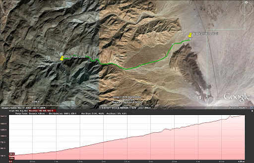
I have wanted to go out to Alma Wash, either for a day trip or camp overnight and explore the mountain tops surrounding Star Fish Cove. The road from Plaster city seems like the quickest way there but I could be wrong. You interested?
<em>edited by dsefcik on 11/4/2010</em> |
11/6/2010
Topic:
Interesting forum thread about Pictograph Rock
dsefcikAdministrator
|
I found this long but very interesting thread about the pictograph rock in Blair valley.
http://www.humancafe.com/cgi-bin/discus/show.cgi?tpc=6&post=725#POST725
It may take you awhile to read thru all of it and it's links but I found it very interesting and made me think more about some of the things I have seen and photographed in Anza Borrego. It also has spurred some more interest in exploring the desert and trying to find out more about the Kumeyaay who lived there so long ago.
Daren |
11/8/2010
Topic:
Solo Backpack to Whale Peak
dsefcikAdministrator
|
That is a great report, thanks! This last weekend was great weather in the desert as proved by all of the visitors and road traffic in Anza Borrego. I also went out for the 4th weekend in a row to ABDSP. My son, dog and I went out late Saturday and camped at Bow Willow and then Sunday we did a full drive tour of the park arriving home late Sunday evening. I have not seen the whole park in a long time and was definitely worth all of the driving.
Hikerdmb, those are great pictures, it makes me want to get up to the top of Whale Peak even more. I am planning on going out again this weekend for 3 days but have no solid plan yet, I am torn between going up Whale Peak, going back out to Inner Pasture and Red Top or hiking out to Starfish Cove. If you are interested in going out this weekend and meeting up let me know.
Your picture of the Laguna mtns took me back a few years when I used to run a lot in ultra distance races, one was the San Diego 100 and went from Lake Morena to the store in Banner and back following the PCT. I always remember getting to the lookout over ABDSP and watching the glider planes soaring quietly over that valley. It is such an awesome view..here is a pic looking back at 'ya

Daren |
11/8/2010
Topic:
U.S. Mormon Battalion Trail
dsefcikAdministrator
|
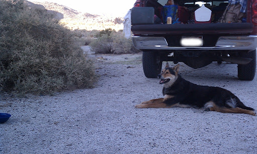
This last weekend I went camping with my oldest son and our dog Rocky "Bones". I don't usually bring our dog because he is just too wild and unmanageable, I don't think there is much "domestic" in him, his focus most of the time is on chasing anything that moves, including coyotes. We did bring him though and managed his extreme desires to chase the jack rabbits, quail and lizards running thru the Bow Willow campground. This was really just a get away for the weekend, we drove out late Saturday and arrived at Bow Willow around 4pm. We only saw 3 other campers there so we picked a spot and made camp which was really only dragging the firewood out of the truck and getting Bones his water dish. The rest of the night was spent just stoking the campfire and enjoying the peacefulness of the desert.
Rocky Bones checking out some quail up on the hill:
I want to say that for anybody who thinks it is too much work to pack up camping supplies and drive for 2-3 hours just to camp out overnight...it is worth it, get out..go..it can't be beat. We heard coyotes howling at night and early morning dawn, saw many jack rabbits and quail and enjoyed a very peaceful night in the desert.
What has any of this got to do with the U.S. Mormon Battalion Trail? (do you even know what that is?) Well, our Sunday consisted of driving most of the ABDSP to do a driving tour and at one stop to let Bones out to walk I saw this sign post:
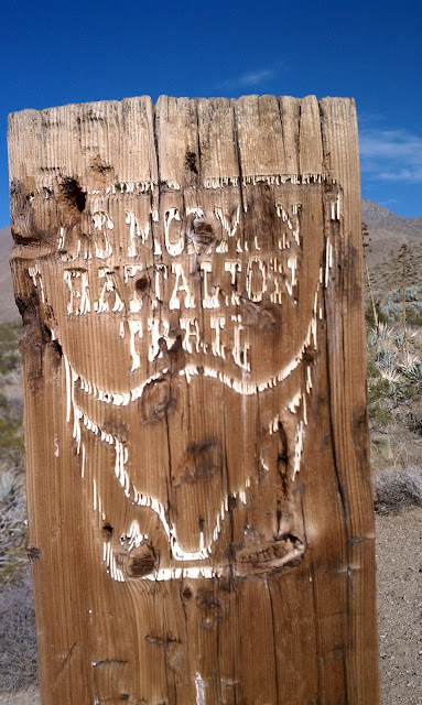
I had never heard of this before and did some research when I got home. This has quite a bit of history, quoting the Bill Sullivan, The Sand Paper, newsletter of the Anza-Borrego Desert Natural History Association, a CCHS member.:
"There was something different about the
battalion of soldiers that marched northward
from Vallecito on the 19th of January, 1847.
Indians had long gone this way. The Mexican
Army officer Santiago Arguello had chased
horse thieves in this direction. The American
General Kearny had passed through here, too.
What was different about these soldiers, the
U.S. Army’s Mormon Battalion, was that their
entourage included five wagons, and numerous
cattle and sheep. The western edge of the desert
wasn’t quite ready for wagons.
The soldiers, tired, hungry, thirsty, many
of them shoeless, had marched for six months
from Council Bluffs, Iowa. After crossing the
Sonoran Desert, they moved from the greenery
of Vallecito (this was five years before the stage
station) and came to the base of the Campbell
Grade. They needed an hour and a half to get
themselves, their livestock (horses, cattle, sheep
and mules) and their five wagons up the grade’s
steep 200 feet and into the Mason Valley. They
then moved on into Box Canyon where they
faced the nuisance of boulders on the ground
and the thorns of mesquite and catclaw, and two
major obstacles.
First, the canyon walls had to be chipped away (with hand tools, mostly
axes) to widen the passageway so the wagons could be pulled through.
Then, to avoid a narrow dry waterfall, a 30-foot wall in the middle of the
wash, they had to build a bypass road up and over a rocky hill full of cactus.
Less than an hour of daylight remained when the beleaguered battalion got
through to Blair Valley. When the commander, Lt. Col. Philip St. George
Cooke, was told that another obstacle, Foot and Walker Pass, stood in their
path, he gave the order to camp in Blair Valley, with the next water seven
miles away at the Indian village at San Felipe Creek.
It was a tough two days, after a strenuous six months, but because of
the soldiers’ work, emigrants to California had a southern route during the
Gold Rush, the Butterfield Overland Mail had a mail route in the 1850s and
’60s, and a few Californians had a route eastward to fight in the Civil War.
When engineers looked for trans-desert routes, they looked here and opted
to go up the east side of the Salton Sea instead. Anza-Borrego’s west-side
rocks were just too tough for them. The route through Anza-Borrego was
left to return to silence, and to us.
Today it’s possible to walk the 20-odd miles from the Vallecito stage
station by way of Foot and Walker Pass to Scissors Crossing, a mile and a
half south of the San Felipe station, but private property forces you to walk
part of the way along the highway. Most of us are likely to approach the
area with short day hikes.
At the north end of the Vallecito Valley, east of Highway
S-2, just before the Campbell Grade, is a small piece of the
state park. A marker stands beside the Mormon Trail. A path-
way, wide enough to accommodate a stagecoach, leads to the
foot of Campbell Grade where the trail becomes faint. Walk
the pathway and imagine how shoeless soldiers got through
the cactus with their bawling sheep and cattle."
There are more websites online that have the complete history of the Mormon battalion group, some are here:
http://mormonbattalion.com/Armyofthewest
http://www.desertusa.com/mag00/oct/papr/mormbat.html
www.californiahistorian.com/magazine2.../25%2027%20SanFelipe.pdf
http://en.wikipedia.org/wiki/Mormon_Battalion |
11/9/2010
Topic:
U.S. Mormon Battalion Trail
dsefcikAdministrator
|
The plaque is still missing, that is where we stopped. Just north of the stone structure is where the sign post is and the trail is visible. I saw many footprints in the wash going thru Box Canyon so it does seem to be a used trail. |
11/9/2010
Topic:
Solo Backpack to Whale Peak
dsefcikAdministrator
|
David, where do you get your weather info for Whale Peak from? Are you just going by similar altitude stations nearby like Ranchita or Laguna? |
11/9/2010
Topic:
Solo Backpack to Whale Peak
dsefcikAdministrator
|
That section of the PCT from Pioneer mail up to and past Lucky 5 is right on th edge of the desert valley and can be extremely windy. Once you drop down into Oriflame and Chariot canyons it calms down but can be really hot during the summer. There are a lot of old mine workings down in that canyon going towards Banner as well.
hikerdmb wrote:
Daren,
I know that view well. We were up there the weekend before last and planned on hiking a section of the PCT to Garnet Peak and back but it was raining and the wind was blowing probably 50 MPH across there so we stayed in the trees and hiked part of the Big Laguna Trail instead and got nice and wet. But it was lots of fun and my dog didn't care that it was raining or windy. Not sure of my plans for this weekend yet but I would love to do a hike with you sometime. It seems you have been some places I have missed in my years of exploring ABDSP.
David |
11/9/2010
Topic:
Peak 6582
dsefcikAdministrator
|
So right now, today, I think this will be my trip out this weekend. I am gonna leave Friday morning, hike out to a potential campsite, hike to the peak on Saturday and finish the trek back to the truck by the end of Saturday. Big fire and beer Sat night and drive back home Sunday.
Daren
<em>edited by dsefcik on 11/10/2010</em> |
11/10/2010
Topic:
Peak 6582
dsefcikAdministrator
|
Hey, no problem Bob, give Mary a "Happy B-day" for me..!
I am also looking at a Sheep/Palm/Cougar Canyon loop instead..will have to decide soon.
Camping at Laguna should be nice, not sure where you go but Cibbets Flats ( http://www.fs.fed.us/r5/cleveland/recreation/camping/cibbetsflats.shtml) is a nice small, lower elevation site I like with access to the PCT for lots of hiking.
Daren
edited by dsefcik on 11/10/2010
<em>edited by dsefcik on 11/10/2010</em> |
11/10/2010
Topic:
U.S. Mormon Battalion Trail
dsefcikAdministrator
|
surfponto wrote:
Great write up Daren,
Amazing Bow Willow only had 3 other campers, especially when the weather is perfect right now.
Did you have to pay a fee to camp there?
Bob
Bow Willow is a "self pay" site and relies on the honor of the campers to pay for their stay. The current fee was $15 and I would swear last year at almost the exact same date it was $12...but I could be wrong with my fading memory. To be honest, this site (for us in our 2 times camping there) has been so clean and the vault toilets so well kept I am amazed it is only a $15 fee site. ABDSP has done an amazing job keeping it so nice, I can only hope it stays that way.
Why camp here instead off road in a no fee area?
* Fire rings - This site has park approved fire rings and you can have a nice camp fire without the hassle of bringing your own metal fire container.
* Vault toilets - OK so it is a toilet on top of a hole...but at least you cant sit down and not squat, besides these are very well kept and clean with TP.
* Bring your dog - you can still walk your dog(s) on the dirt roads and have plenty of walk time without violating park rules.
* Plenty of hiking and exploring up to Sombrero Peak or some Palm Canyons while enjoying all of the above amenities.
May not sound like much but if you have endured other primitive state/fed parks you will see the difference.
Daren |
11/15/2010
Topic:
New Software upgrade
dsefcikAdministrator
|
Just left a comment..maybe I am old school or just old fart but I have not heard of Disqus and was surprised there was no gmail auth or auto avatar. Anyway, good to see the comments fixed, now maybe a more robust forum WYSIWYG editor?? |
11/15/2010
Topic:
New Software upgrade
dsefcikAdministrator
|
Just signed into Disqus..interesting. |
11/17/2010
Topic:
New Software upgrade
dsefcikAdministrator
|
NP, I know how upgrades go...now, how about that new fancy wysiwyg editor for the forums?? |
11/17/2010
Topic:
Thanksgiving week break trips
dsefcikAdministrator
|
Anybody going out for Thanksgiving week? I know I mentioned a Carrizo Gorge backpack trip, anybody still want to try that? It needs two cars so I can't do it alone. I want to go out this coming week and have a few plans already drawn up. Probably the biggest one is a tour of Collins/Rockhouse Valley. It could be a 2 or 4 day backpack trip.
Let me know if you are interested or will already be out hiking or camping and maybe we can hook up.
Daren
edited by dsefcik on 11/17/2010
<em>edited by dsefcik on 11/17/2010</em> |
11/17/2010
Topic:
Thanksgiving week break trips
dsefcikAdministrator
|
I never saw the attachments link until today so I tried it out. It seems to cut off the lower 3rd of the images when I download them but the thumbnail looks right. Bob, is there some size/dimension limit or do you know why that is happening? |
11/18/2010
Topic:
Jacumba Wilderness
dsefcikAdministrator
|
1. Thanks for the great info David!
2. I am surprised the Reader still exists and even more surprised Schad gets away with putting his book trails in there (com'n everyone, buy his book! I have every one of them from 1987)
3. Every time I drop down into AB I have a momentary last minute thought of swerving off onto the Mtn Spring exit and start scrambling those rocks.
4. I think an even more interesting area would be just west of the nudeness camp where there are fences keeping you from entering, I bet that area has lots of history.
5. Did you know Schad is a sub 24 hour finisher of the WS 100 mile ultra race??!! Take his difficulty ratings with a grain of salt....
6. Yeah, count me in..maybe I'll get some snake boots for the spring.
PS, a few weeks ago when I was out there I saw a whole fleet of BP agents driving that area and now after watching NG's Border Wars on TV the last few months.....hummm.... |
11/21/2010
Topic:
The View from Monument Peak
dsefcikAdministrator
|
That is crazy, how did you find that video??
Great pics..I am packing up the truck now getting ready to head out tomorrow. In your pic of WP you can see Bisnaga Alta Wash and how the potential climb up the alluvial fan would go. That is also a great view of Vallecito.
Daren |
12/3/2010
Topic:
Jacumba Wilderness
dsefcikAdministrator
|
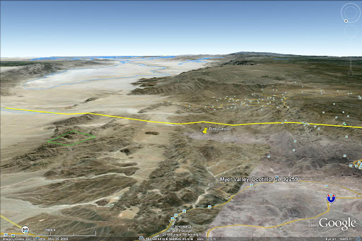
Bob, I will be at the rally if nothing major comes up. I suggest instead you/I take the opportunity to just mozy on over across the road from the rally to Sacatone Overlook and hike down to the Palm Grove you have been wanting to go check out for so long. The overlook is 2 miles east on a dirt rd from the sign in McCain Valley. If not I would be up for the myer valley hike also.
Daren |
12/3/2010
Topic:
Jacumba Wilderness
dsefcikAdministrator
|
that was a cute if not drama filled story, not sure i would use it for a hiking guide though. it doesn't look like his pictures are online anymore, shame as his site shows he knows how to take good pictures. i think i still ditto my previous comment about the Reader.
Thanks for link David, good reading..!
hikerdmb wrote:
Bob,
Here is the link to the Reader article I couldn't find before.
http://www.sandiegoreader.com/news/2009/jun/03/cover/
It seems like the rock art here is petroglyphs and not pictographs but I can't find any of my old pics to be sure. The Reader article may have some useful info for you. I also sent you a PM to your ***runner account with an attachment of a topo map of the area and some more info.
David |
12/3/2010
Topic:
Jacumba Wilderness
dsefcikAdministrator
|
Based on the Reader story I pinned Pinto Canyon on GE and made an image looking south towards Mexico. I could see that entire are filled with water hundreds of years ago and a ship sailing up from the Gulf. Check out how many pictures in Panoramio there are of La Rumorosa...dang. It definitely looks like Clark Lane would be the way to go but the article says BLM has closed it.
 |
12/5/2010
Topic:
Jacumba Wilderness
dsefcikAdministrator
|
Check out this guys pics and links:
http://nexthill.com/Photo's/Pinto/index.htm
http://nexthill.com
Sorta almost makes me not want to go there after seeing all the trash in his pics.
And technically, it is not part of ABDSP, it is BLM
http://www.blm.gov/ca/pa/wilderness/wa/areas/jacumba.html
--
<em>edited by dsefcik on 12/5/2010</em> |
12/7/2010
Topic:
Bighorn Canyon
dsefcikAdministrator
|
I have not been there but have studied the area, there is a loop possibility using the jeep road also but it would be longer than 7 miles total. I am not sure if you are talking about the wildlife guzzlers (bubbler/watering system) but I have been out to the Table mtn area and know where those are, near the towers and believe that is what is near Blue Spring. If you want some company let me know, I wouldn't mind getting out there this weekend.
Daren |
12/7/2010
Topic:
Indian Valley 11-2010
dsefcikAdministrator
|
My son and I went out for a couple of days to Indian Valley over Thanksgiving break. I wrote a TR on my website:
http://www.sefcik.com/2010/12/indian-valley-anza-borrego-desert-state.html
We only had a couple of days and had a good time even though it was really cold and windy, I think I like the summer better.
Found what I think was an old Indian hunting blind and some rock carvings and I made a new desert friend.
This guy was under my sleeping bag in the morning

Rock carving and hunting blind


Daren
--
<em>edited by dsefcik on 12/7/2010</em> |
12/8/2010
Topic:
Counting SHeep
dsefcikAdministrator
|
Link to the 2009 Bighorn Sheep count totals, kinda interesting.
http://theabf.org/files/images/2009_SheepCount.pdf |
12/10/2010
Topic:
Counting SHeep
dsefcikAdministrator
|
I wouldn't mind doing it, if you know where to get more info for volunteering can you post it? |
12/10/2010
Topic:
Tule Mtn
dsefcikAdministrator
|
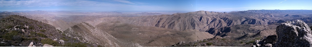
After booing at all of the Sunrise Powerlink executives and visitors to the SPL ground breaking I went out and hiked up Tule Mtn which was right down the road. Bob was supposed to go with me but he had to go back to work...bummer. It was a great day, t-shirt and shorts weather at 4,647' in December. I'll need to write a proper report after I get the pictures ready but here is a panorama of Carrizo Gorge from the top of Tule Mtn. It really is an incredible view.
Download the full image (4904x740) here: https://sites.google.com/site/darensefcik/downloads/Carrizo_Gorge_From_Tule_Mtn_Panorama01.jpg
Daren
--
<em>edited by dsefcik on 12/10/2010</em> |
12/14/2010
Topic:
Tule Mtn
dsefcikAdministrator
|
Not too hard, I used the Pandora Plugin with The GIMP on a Linux machine.
Life is easy on Unix.
surfponto wrote:
Ok you have to show me how you stitched together that panoramic.
That is incredible.
Bob |
12/14/2010
Topic:
Backpacking in Bighorn Canyon
dsefcikAdministrator
|
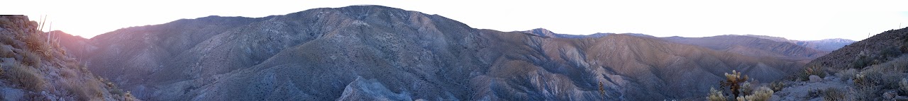
David, thanks for letting me tag along on your trip, I enjoyed hiking with you and your buddy. No less than 30 minutes after I got home did 2 coyotes show up in my back yard and start taunting my dog...wild I tell you..I will try and post some photos when I get a chance, below are 2 that I took, one is a panorama from the peak I climbed up in the morning and another is one of the many sheep scat droppings I found, they were everywhere. The third is the gps trip route in google earth.
Sheep scat, there was scat everywhere and I even found a few scraped up areas indicating a possible bedding area

Panorama of Bighorn Canyon. You can see Granite Mtn (U shaed peak right of center), Pinyon Mtn (center) and Toro Peak (far right). If you go to the Download full sized panorama here you can download the full sized image to get the full perspective of it.
GPS route
--
edited by dsefcik on 12/14/2010
<em>edited by dsefcik on 12/14/2010</em> |
12/14/2010
Topic:
Backpacking in Bighorn Canyon
dsefcikAdministrator
|
hikerdmb wrote:
Is the elevation total from your GPS for our hike correct? That is a different number than you had said after the hike. The total on your track is closer to what I had on my altimeter.
I pulled the gps info into google earth and added our side trip to the spring. I would guess it is somewhat accurate, I may have been reading the gps wrong when we were out there.
-- |
12/15/2010
Topic:
Backpacking in Bighorn Canyon
dsefcikAdministrator
|
Attached to this message is the Garmin software profile of the route, I would tend to believe that. Also, I added in the little hop we did over to the tanks and back to our packs so what I read on the gps would by slightly less than what is showing here.
dsefcik wrote:
hikerdmb wrote:
Is the elevation total from your GPS for our hike correct? That is a different number than you had said after the hike. The total on your track is closer to what I had on my altimeter.
I pulled the gps info into google earth and added our side trip to the spring. I would guess it is somewhat accurate, I may have been reading the gps wrong when we were out there.
-- |
12/15/2010
Topic:
Backpacking in Bighorn Canyon
dsefcikAdministrator
|
David, thank Andy for me for sharing those, they are really amazing..I need to get me one of those cameras (and maybe buy a book or something). I learned a lot about cameras and the night stars on that trip, I am glad I was able to join you guys. Also,I looked up the Nolina plant and I believe you are correct about the one we saw, long thin pointed leaves.
From superstock.com
"Close-up of a nolina plant, Anza Borrego Desert State Park, California, USA"

--
<em>edited by dsefcik on 12/15/2010</em> |
12/16/2010
Topic:
Old Cabins in Aznza Borrego
dsefcikAdministrator
|
Welcome! I have never been there but the Lindsay book mentions something about old cabin ruins near Clark Dry lake, I am guessing that is what you have the pictures from? |
12/17/2010
Topic:
FEDERAL JUDGE HALTS FIRST LARGE-SCALE SOLAR PROJEC
dsefcikAdministrator
|
http://www.eastcountymagazine.org/node/5023
eastcountymagaizine.org:
"Judge grants Quechan Indian tribe’s request for temporary injunction on Tessera Solar plant in Imperial Valley; decision has ramifications for large-scale energy projects in East County and across the nation"
This is a win for Anza Borrego and the Quechan tribe. |
12/17/2010
Topic:
Old Cabins in Aznza Borrego
dsefcikAdministrator
|
I am trying to visualize where this is, if Toro Peak is south than you are north of it..which puts you much more than "a bit" outside of ABDSP, that would put you way into the Santa Rosa Mtns or near Pine Mtn. Or is that more south'ish and you are still in Martinez Cyn somewhere?
Great pics, thanks for sharing!
6kmclimber wrote:
From Feb 1993 trip. Again a bit outside ABDSP to the north. You can see El Toro peak to the south. Cheers
[IMG]http://i67.photobucket.com/albums/h294/metalmeister/ABDSP/CopyofPCTrockhouse2-6-1993007.jpg[/IMG]
|
12/18/2010
Topic:
Backpacking in Bighorn Canyon
dsefcikAdministrator
|
I was in Walmart buying dog food yesterday and saw this camera for $499 (XSi), it came with the 18-55mm lens. Craigslist has lots of them also. Guess I need to start saving my pesos.
hikerdmb wrote:
Bob,
Andy said go ahead and put a couple on the blog. He checked out your site and thought it was cool. His camera is a Canon Rebel xsi, and the lenses are a Canon 10-22mm (this is the one used for most of the pics, including all of the night sky ones), Canon 60mm, Canon 18-55mm, and a Canon 75-300mm.
David |
12/19/2010
Topic:
Old Cabins in Aznza Borrego
dsefcikAdministrator
|
OK, that makes sense then. I say close enough, no worries..glad you took time to post them, I would like to know more about Martinez canyon. Did you enter/exit via ABDSP or from the east somewhere?
6kmclimber wrote:
dsefcik
You are correct. The last rockhouse/cabin is about 12 miles to the north of Torro peak and is a more than a bit out side of ABDSP. Administrator, don't ban me yet I just joined
Anyway I just thought is was a neat ol' homestead. Inside was completely full of cobwebs and provisions looked like from the 50's. There was a nice seasonal creek real closeby and
grid holes, pot sherds everywhere. Probably a native spring/fall camp on thier way up and down the mountians. I will try to future keep posts closer to ABDSP. Even our beloved Rabbit peak, Santa Rosa indian Ruins, Cactus spring, etc...... are outside ABDSP and in the "Other "county |
12/19/2010
Topic:
Rock Art in the Anza Borrego Desert
dsefcikAdministrator
|
I don't see this as an official link anywhere on the main website, I had to come back here to find it.
surfponto wrote:
Not that i am an expert by any means but I decided to create a page that shows a lot of the pictographs, mortereos etc. out in Anza Borrego.
If you have any to share just email them to me or link them in the forum so I can post.
Thanks,
Bob
Native American Rock Art in the Anza Borrego Desert |
12/21/2010
Topic:
Peak 6582
dsefcikAdministrator
|
When you cross Clark Dry Lake there is an old engineering marker "Corp" (it is also on topo maps) and it has some glyphs there. It is also mentioned in Schads book.
I have not made it out yet, I was gonna go out to Rockhouse Cyn this week but th weather has derailed that plan. I will try to go after Christmas.
surfponto wrote:
OK you have my interest :-)
What are the "corp" petroglyphs?
Bob |
12/22/2010
Topic:
Rain
dsefcikAdministrator
|
My plans this week have been completely shot, I will try to go out next week, probably Sun or Monday or even possibly tomorrow for a quick view. Do you think CDL road will be passable? I have never been on that road.
I drove a few hours yesterday out thru the backcountry of Alpine/Descsnso/Jamul/Skyline and it was also a mess, many,many floods and water falls.
I will say, I am still amazed how people drive in this weather, I stayed off the freeways but saw 2 roll over's on the 94 from frontage roads on the way home. |
12/22/2010
Topic:
Rain
dsefcikAdministrator
|
A couple of pics from walking my dog this morning and also my backyard. I took all of the pics with my phone.
Flooded street near my house, people were stuck in this closed condo community
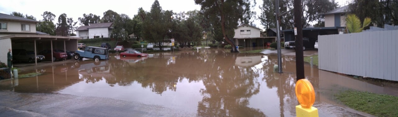
Chollas Creek in front of my house, the hillside totally caved in and the fence is falling
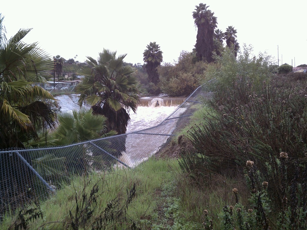
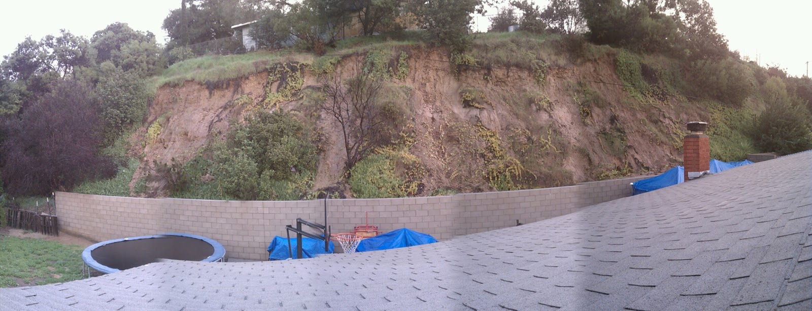
The hill in my backyard (taken from the roof), good thing I finally built the retaining wall but still a mess for sure. Five major slides came down and my crazy dog was trying to chase the falling rocks all night.
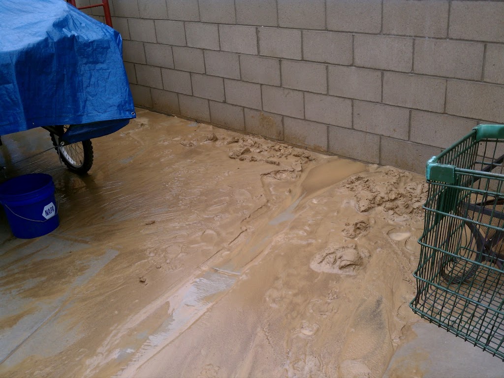
Even the silt was pouring out the drain holes at the bottom of the retaining wall, I still have a lot of cleanup to do. All of that dirt/silt came thru cracks about 1/2"x1/2" and even now are still flowing out.
 |
12/22/2010
Topic:
Rain
dsefcikAdministrator
|
hikerdmb wrote:
Daren,
The creek picture is pretty amazing. Urban kayaking?
David
The creek is a longer story but kayaking is not possibly due to all of the garbage people throw in it.
You can see the video (from my phone) of the rain storm water flow here:
http://www.youtube.com/watch?v=-xA0vxrXsoU
Or even more fun (not for faint of heart) of the pictures I took this year walking my dog in the canyon. Caution, many coyote kills are shown, not for the squimish.
http://www.youtube.com/watch?v=e_Dg0Ux1n7s
-- |
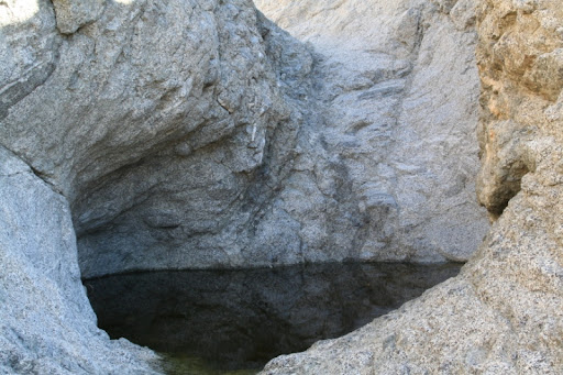
12/30/2010
Topic:
Smoke Tree Canyon / Calcite Mine Area
dsefcikAdministrator
|
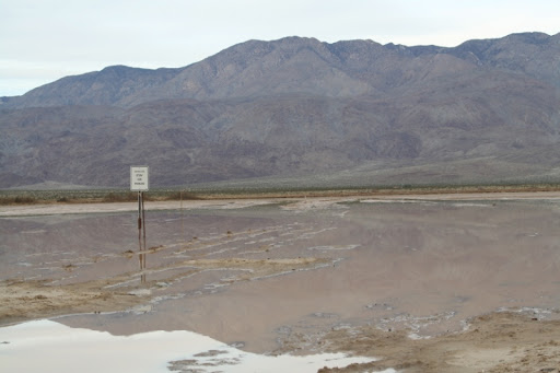
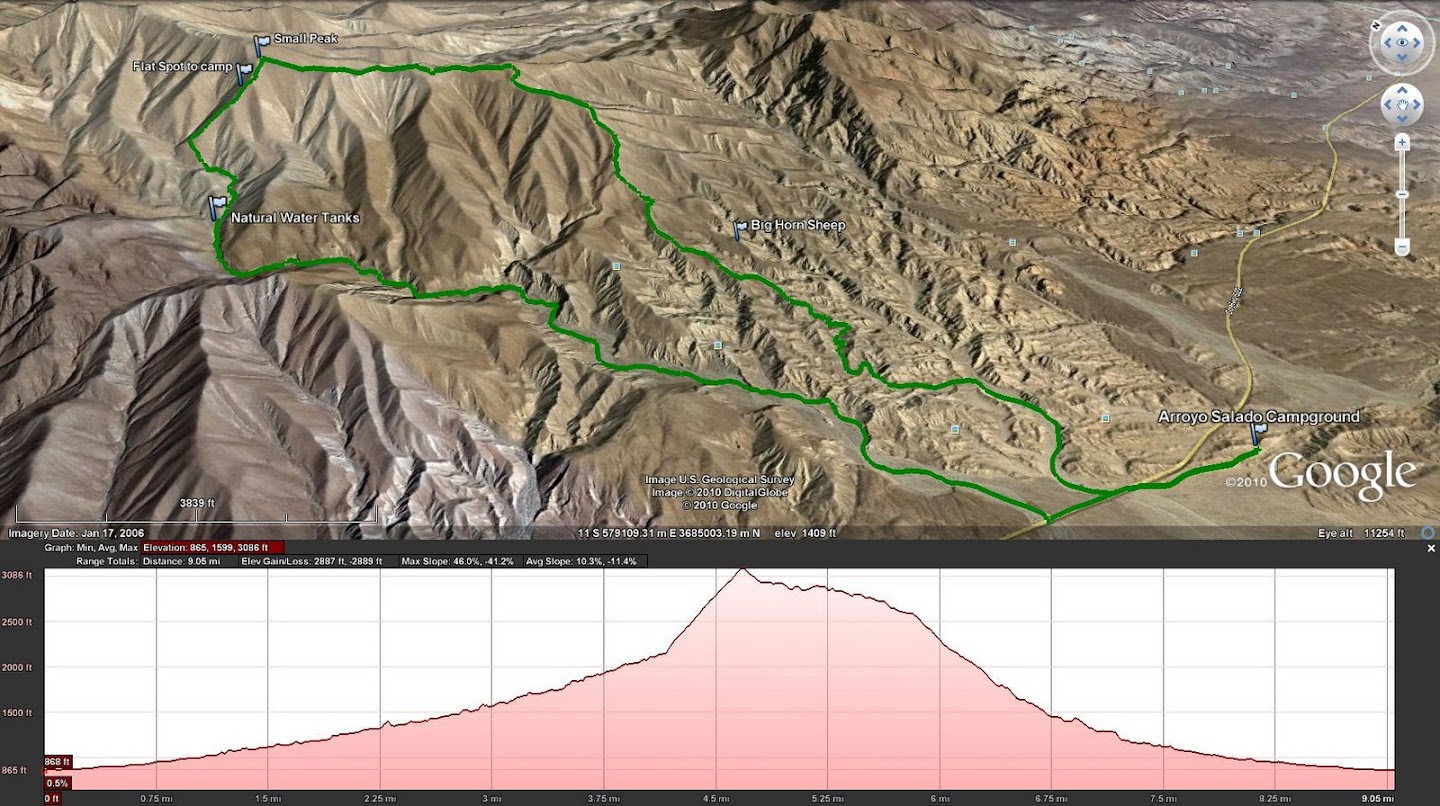
So the first week of winter break was a disaster with the weather but the Sunday after Christmas I packed up and got out of dodge as fast as I could. I was gonna backpack into Rockhouse canyon but as my luck seems to be I could not. Clark "Dry" Lake was flooded and the road was not passable beyond the rock crushing machine. It was getting dark and I needed to camp out somewhere so I kept driving east. I did not camp near CDL because there were already a ton of people, mostly RV's out there. Most of the washes east of CDL were also all muddy and not car friendly looking, there was a jeep stuck floorboard deep on the shoulder at Fonts Point, 2 other jeeps were winching him up and trying to pull him out...3 feet from the road. Goes to show you that anyone can get stuck anywhere, doesn't need to be way off in the back country roads somewhere. I rolled into Arroyo Salado campground and made camp just as it was getting dark. I ended up camping here for 3 nights before driving home Wed morning just as it started to rain heavily.
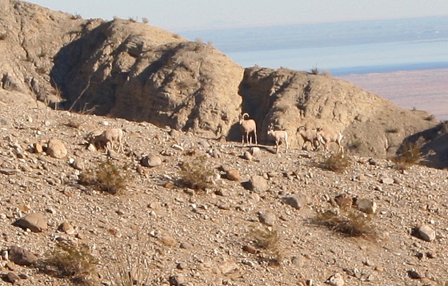
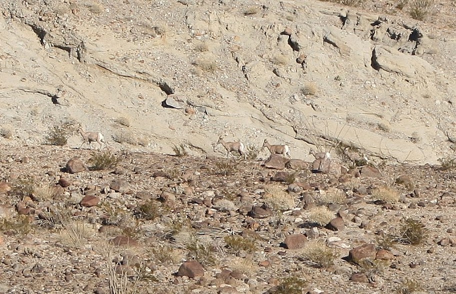
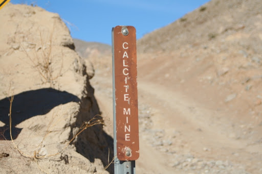
Monday I hiked hiked up Smoke Tree Canyon to check out the Natural Water Tanks (or "Tinaja" as some say) and then free styled it up an unknown peak and back down thru Coachwhip Canyon. This was a great hike of about 10 miles and as a bonus I saw a herd of Bighorn Sheep. It looked like 3 adults and 2 younger ones. The views were awesome from the peak (which I believe was right next to Pyramid Peak). Tuesday I hiked out near the Calcite Mine area and thru one of the slot canyons. I returned back down thru Palm Wash and more slot canyons.
This was the most time I have spent in the north half of ABDSP and 2 things I noticed immediately:
1. No Border Patrol
2. A lot more people, especially the RV and OHV crowd
It was a great trip and I can see tons of great hiking possibilities all thru the Santa Rosa Mtn areas. I also decided to borrow a Canon DSLR from a friend on this trip, while I do not have anywhere near the talent Andy has I tried my best to snap off a few good photos. Without this camera I would not have been able to photograph the Bighorn sheep.
Here are a few pics from the trip;
Clark "Dry" Lake road
Tinaja in Smoke Tree Canyon
Bighorn Sheep on the ridge across from where I was, there are 5, 3 adults and 2 young ones
Bighorn Sheep as they mosied off up the hill
Calcite Mine Rd sign
Slot Canyon near Calcite Mine
Deep gouges in the earth from the Calcite mining operations during WWII
Some Creosote and a view of Travelers Peak from the Calcite Mine road
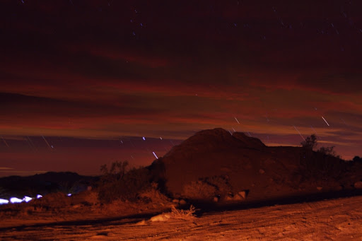
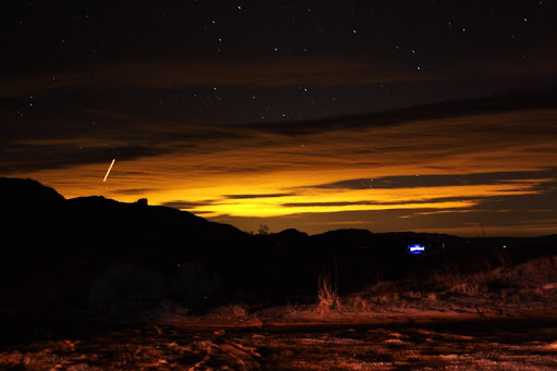
My feeble attempt at star trails from the campground, I had to use 30 second exposures and then then stack them together in a photo editor program. The bright amber lighting is from my campfire blazing behind me and the bright light on the lower left is from a late night camper driving thru camp
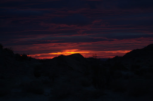
Sunrise Wed morning, the clouds were rolling in all night and it started raining by early AM
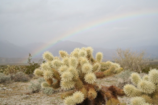
A little cactus and rainbow near the Vallecito Mtns on my drive home
GPS route of the Smoke Tree Canyon Hike
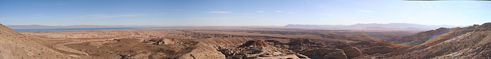
Panorama of the Salton Sea and Borrego Valley from the "Locomotive" rock near the Calcite Mine
--
<em>edited by dsefcik on 12/30/2010</em> |
12/31/2010
Topic:
Backpacking in Bighorn Canyon
dsefcikAdministrator
|
David, you should tell ANdy to check the ABF photo contest, they have a new "desert at night" category. Entries are due Jan 31'st 2011.
http://theabf.org/events/photo_contest |
12/31/2010
Topic:
Smoke Tree Canyon / Calcite Mine Area
dsefcikAdministrator
|
There were many tanks of varied sizes, probably at least 8-10 or so. I wanted to try and get over to the sheep tanks east of the calcite mine but it was late in the day and I did not see an immediately obvious or easy way to get over to the Palm Wash side of the canyon from the mine area. I will do that on another trip. The bighorn sheep were probably at least a couple hundred yards away, you can see in the gps route they were across a ridge. I had just stood up from taking pictures of sheep scat (a lot of it) and saw them. They stared at me for awhile and then slowly walked away and up the mountainside. I think next weekend will be fine if there is no more rain, pretty much every single wash that crossed the highway had a "Flooded" sign and Caltrans was out Wed morning scraping the highway clean. It definitely flash flooded that whole area but there was no running water, just lots of mud and large standing water mud pits (like the one the jeep got stuck in).
Here are a few more pics
Bighorn Sheep scat and bedding area
What I believe to be possibly part of the old native american trail system that I have read about in numerous publications. I happend upon this descending into Coachwhip Canyon and I could see it heading off towards Travelers Peak and the Calcite mine area. I saw no signs of humans anywhere up in this hillside, it was only until I got down in the canyon area did I see human tracks.
Sheep tracks leading up this plant shows they were munching on it
Lots of sheep tracks down in the wash

Calcite minerals near the Calcite mine area
 |
12/31/2010
Topic:
New lights for Christmas
dsefcikAdministrator
|
Pretty sweet looking..do you actually drive off road much at night though?? |
12/31/2010
Topic:
Smoke Tree Canyon / Calcite Mine Area
dsefcikAdministrator
|
hikerdmb wrote:
That definitely looks like an old Indian trail. Here is a pic of an old trail we came across above the upper part of Arroyo Tapiada. It had some huge rock cairns every hundred yards or so. Did the trail you found have any cairns like this? You can see one of the cairns to the left of the ocotillo and the trail runs on into the center of the pic.
No, I did not see any cairns. I read there were native american trails all across the santa rosa mtns, some going to/around travelers peak and pyramid peak and I think this may be part of that. I could see from far up what looked like a faint animal path and as I followed a natural course down the mtn I ended up on this trail. I only followed it briefly as it headed east and I was going south, down the mtn.
Here are a couple more pics from the trip, I took probably 800 or so just messing around with the camera I borrowed so I have been sorting thru them all the last couple of days.
Another sunset shot from Arroyo Salado Campground. The blue light is the glow from inside an RV parked across the way and the streak in the upper left I believe was an airplane. This was a single 30 second exposure shot.
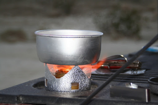
Here is a shot of my newly purchased Trangia backpack stove. I have used it a few times and it is an amazing little stove. If you are looking for a small, inexpensive and easy to use stove you should check one out.
--
<em>edited by dsefcik on 12/31/2010</em> |
1/1/2011
Topic:
Smoke Tree Canyon / Calcite Mine Area
dsefcikAdministrator
|
surfponto wrote:
Hey Daren
Great night shot. Looks like you are figuring it out. What camera is that?
Also what is the detail on the stove? Looks pretty cool.
Bob
It is a Canon Rebel XT with a cheapo Tamron lens. In skilled hands I am sure it can produce great photos..I am just trying to understand it. The Trangia I bought with mucho skepticism but for $40 at REI and nothing but positive reviews online I bought it..no regrets so far. My needs are simple, boil water and heat canned food..it does both of these without flinching.
More info here:
http://www.rei.com/product/657906
-- |
1/6/2011
Topic:
Tule Mtn
dsefcikAdministrator
|
I posted a few more pics but nothing spectacular
http://www.sefcik.com/2011/01/mount-tule-sunrise-power-link-protest.html |
1/6/2011
Topic:
El Cajon Peak (AKA El Capitan Mtn) Hike
dsefcikAdministrator
|
I was thinking of hiking El Cajon Peak this Sat 01/08/2011, anyone interested in joining in on the fun? Last time I hiked it was during the summer and it was 108 degrees on my truck gauge in the parking lot, can't say it was all that fun so I would like to go again in the cool weather.
If you are not familiar with El Cajon Peak here is a link to checkout:
http://www.shyamal.com/Hikes/ElCajonMt/ElCajonMt.html
I also just saw this but I am afraid I wont be going:
http://www.eastcountymagazine.org/node/5179
<em>edited by dsefcik on 1/6/2011</em> |
1/9/2011
Topic:
El Cajon Peak (AKA El Capitan Mtn) Hike
dsefcikAdministrator
|
I was able to get out today and hike it. It is hard even on a cool day (I was wearing my 50lb pack fully loaded though).
http://www.sefcik.com/2011/01/el-cajon-peak-el-capitan-open-space.html


--
<em>edited by dsefcik on 1/9/2011</em> |
1/10/2011
Topic:
Rockhouse Valley via Rockhouse Canyon
dsefcikAdministrator
|
surfponto wrote:
Just posted a new trip report on the site.
Just gives a 404 error..where did it go?? I remember it was there before. |
1/10/2011
Topic:
El Cajon Peak (AKA El Capitan Mtn) Hike
dsefcikAdministrator
|
hikerdmb wrote:
Looks like a great hike? How long did it take? I've looked up that way many times but never knew there was a trail going up there. Good pics on your site too.
David
It was a 6 hour hike both times I did it. The first was in the heat and the second was with a heavy pack so I guess they balanced out. It is a tough hike for sure, I just wish it had been more sunny yesterday. The pics are from (my) new camera. I bought used dslr after christmas. Andy motivated me to finally buy something that will allow me to take higher quality photos, now I just need to learn how to use it.
You need to write up a TR of where you went with your new lights. |
1/11/2011
Topic:
Clark Valley Petroglyphs
dsefcikAdministrator
|
Nice trip..that kid reminds me of me about 30 years ago when I got my first car, a CJ5. I promptly got it stuck in a big mud pit thinking it was invincible...haha..I was actually just looking at my CDL pics and was trying to remember if the entrance/road thru that gravel yard place allowed us to drive thru to get to the more west'ish side of the road where it was dry but I cannot remember now..is that where you drove thru to get around the lake? I stayed on the marked rd and there was a sign indicating that you should veer right thru the lake/mud area and it was flooded out for me. Also, I believe (from reading various articles) there are more indian occupation artifacts further into the hills and valley areas near there and I will be trying to get out there soon to explore once the road clears up enough for me to get thru.
This is where I stopped (and I think you found the stuck jeep), did you go left from here thru the fenced area and follow the road to the foothill? Google Earth clearly shows a road there.
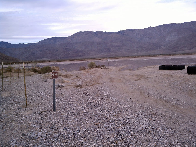 |
1/11/2011
Topic:
Clark Valley Petroglyphs
dsefcikAdministrator
|
I bet the ducks you saw are a path up to peak 6582 (which I posted about here)
The artifacts I am thinking of are much further north-west, towards rockhouse valley but not quite there. I do want to get out there and am trying to make plans this weekend. My son may go with me so I will see. |