|
tekewin Posts: 385
4/23/2019
|
My last hurrah in the desert before summer. Benchmark hunting west of Salton Sea. I was looking for two benchmarks above Big Wash (Hot and Cool), and another one somewhere in the hills below Travelers Peak (High). I planned a route from Big Wash off highway 86. I made a few mistakes that made for a longer day and I may have crossed part of a closed area. There were some signs along the jeep trail in Big Wash but I've seen those on other trails referring to a deep sand area, etc. so I didn't pay attention until the way out. More on that later.
The road into Big Wash started off in poor condition, then got better. High clearance and 4x4 recommended. I parked a few miles in then headed for the north ridge of Big Wash where Hot BM was placed.


Looking back down Big Wash from Hot
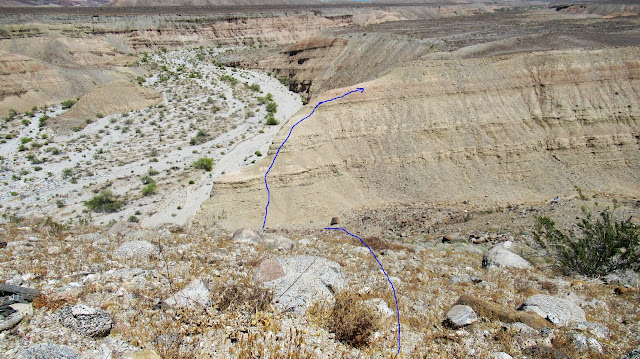
Next, I headed along the top of the ridge toward Cool, two plus miles away. Moving along the top of the ridge was easy and open and looked a lot better than navigating the wash below. The ridge was broken in one place before Cool where erosion had created a 100' drop. It wasn't too hard to get down and back up the other side. A little more ridge walking got me to Cool where another tiny register lived. The first page of the register was a pre-printed form placed by the Borrego Benchmark Club. I don't think I've seen one of these before, or didn't notice. I took a break at Cool and enjoyed the views of harsh terrain all around. The east side of Travelers Peak looked interesting.


High benchmark was less than two miles away (as the crow flies) and 1000' above Cool somewhere in the cluster of hills to the west. As I reached the right elevation, I made my second big mistake. Instead of tracking to the exact location in my GPS, I hiked up to a nearby high point and found nothing. I checked the GPS, then headed to the next nearby high point, then thee next through the intervening gullies. I ended up wasting about 30 minutes visiting every high point and ridge line in frustration. High was near a low point on one of the ridges and I finally found it by strictly going to the GPS coordinates. It was there on a flat rock with a downed wooden pole.The view back to the Salton Sea was now less hazy and quite impressive. When I started back, I took a long gully I had avoided on the way up. It had accumulated some boulders that actually made descending easier. I thought about dropping all the way into Big Wash to the return trip, but it looked more difficult than just staying above it.I picked up three mylar balloons during my trip.


Ridge break heading back

Back to the sign, it referred to a State Park order that I could not find on the Anza-Borrego web site, the CA state park web site, and even Google couldn't find it. The order closed a section of park in 2013 above Grave Wash and into parts of Big Wash. I think it was part of the Freeman land grant, but Internet searches returned vague info. So, the restriction might still be in place, not sure.
|
|
|
+1
link
|
|
Rocko1 Posts: 615
4/23/2019
|
Nice report. Love seeing the older summit logs.
|
|
|
+1
link
|
|
Buford Posts: 467
4/23/2019
|
Cool. I think the Borrego Benchmarks Club has something to do with the San Diego Peaks Club or a predecessor to the Monday Maniacs.
--
Links to my photos: ABDSP photos, Bighorn sheep photos, ABDSP time lapse video, Wildlife photos (mainly birds)
|
|
|
+1
link
|
|
dsefcik Administrator Posts: 2634
4/24/2019
|
Nice Balloon collection...I love the benchmark names, a couple favorites are still Shake and Quake in Earthquake valley. Shake gets little visitation.
--
http://www.sefcik.com
http://www.darensefcik.com
http://www.carrizogorge.com
|
|
|
+1
link
|
|
tekewin Posts: 385
4/24/2019
|
dsefcik wrote:
Nice Balloon collection...I love the benchmark names, a couple favorites are still Shake and Quake in Earthquake valley. Shake gets little visitation.
Yeah, I love the names, too. It would have been great to get Low with High, but Low was too far away. I'll look for Shake in the fall.
|
|
|
link
|
|
rockhopper Posts: 672
4/24/2019
|
Nice hike over the desert patina. Did you see any old faint trails heading west towards the mountain canyons?
|
|
|
link
|
|
tekewin Posts: 385
4/26/2019
|
rockhopper wrote:
Nice hike over the desert patina. Did you see any old faint trails heading west towards the mountain canyons?
There was a partial faint trail on the plateau between Hot and Cool. It continued past Hot where I dropped back into Big Wash. On the other side of Cool was another faint trail heading further up canyon, but I lost it in a half mile. There was nothing as I headed up to High BM.
|
|
|
link
|