|
AdventureGraham Posts: 170
11/27/2012
|
I would like to get out again for a hike that I did back in June. On my last hike out from McCain Valley to Sombrero Peak I ended up bypassing my intended destination and wound up a bit North of the peak. So this time around I'm planning on doing it right.
I would like to get an early start this Saturday morning. The trail head is Cottonwood Campground off McCain Valley Road, 12.7 miles northwest of intersection with Old Highway 80. This hike isn't as tough as the one out to Goat Canyon, but there is a bit of boulder scrambling up to the peak summit. If anyone's interested in coming along feel free to post up!
Date: December 1st, 2012
Distance: 9.0 miles round trip
Elevation gain/loss: 1300'/1300'
Hiking Time: 6 Hours
Difficulty: Moderate
Trail Head: Cottonwood Campground
Directions:
From Interstate 8, take the 94/Boulevard exit (Ribbonwood Rd).
Proceed south to the first stop sign.
Turn left/east on Old Highway 80.
After approximately 2 miles, turn left on McCain Valley Road.
Follow McCain Valley Road 12.7 miles north to Cottonwood Campground (on the right).
|
|
|
link
|
|
surfponto Administrator Posts: 1369
11/27/2012
|
That looks like a great hike John. 
You are doing it from the more difficult side unlike when we hiked up to Sombrero Peak from Indian Valley a few years back.
Be sure to post your trip.
I would like to see what it looks like from that side
I would like to join but we may be doing a MTB ride out to Goat Canyon.
--
https://www.anzaborrego.net/


|
|
|
link
|
|
ziphius Posts: 911
11/27/2012
|
John,
That is a nice route to Sombrero. There is a great (I hope it is still there) gnarled, bonsai-like specimen of mountain mahogany growing out of a crack in a boulder almost at the summit. It's my favorite individual plant in the whole of ABDSP. Please pay my respects to it if you see it. It is likely over 100 years old. - Jim

edited by ziphius on 11/27/2012
--
http://www.coyotelearning.org
|
|
|
+1
link
|
|
dsefcik Administrator Posts: 2634
11/27/2012
|
Hey John, that is a good hike. If you follow the trail then jeep road you will be fine until the last 1-1/2 miles or so, just keep heading towards the peak and you will get there. I had someone who went out there recently tell me they could not find the register so I am curious if you do, it should be an old army ammo case chained to a boulder.
--
http://www.sefcik.com
http://www.darensefcik.com
http://www.carrizogorge.com
|
|
|
link
|
|
tommy750 Posts: 1077
11/28/2012
|
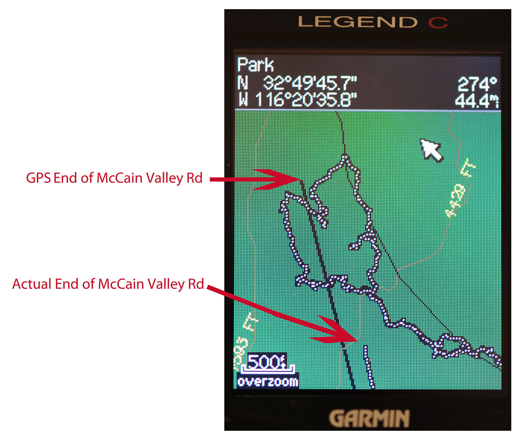
Don't feel too bad about getting off track out there. Here's a pic of returning from my first hike to Sombrero from the West. Was parked at the end of McCain Valley Rd. Forgot to turn on the GPS at the vehicle, but no problem I thought. Since the end of McCain Valley Rd is much higher than the trail and surrounded by a hedgerow of dense 10-15ft brush, I got really disoriented. Clawing through the brush in the dark wih the temp dropping and my young companion increasingly disillusioned with my wilderness prowess, it was a disheartening moment realizing even my GPS was lost. Our actual position was hundreds of yards away from the GPS map location. Could have saved the day using the GPS coordinates with my printed topo map but it fell out of my backpack on the way back  Lots of lessons learned that night! If you make it to the junction of Canebrake Rd and the old 4WD road and head due East, you'll have no problems. Tom Lots of lessons learned that night! If you make it to the junction of Canebrake Rd and the old 4WD road and head due East, you'll have no problems. Tom

McCain Valley Miss by tomteske, on Flickr
edited by tommy750 on 11/28/2012
|
|
|
link
|
|
dsefcik Administrator Posts: 2634
11/28/2012
|
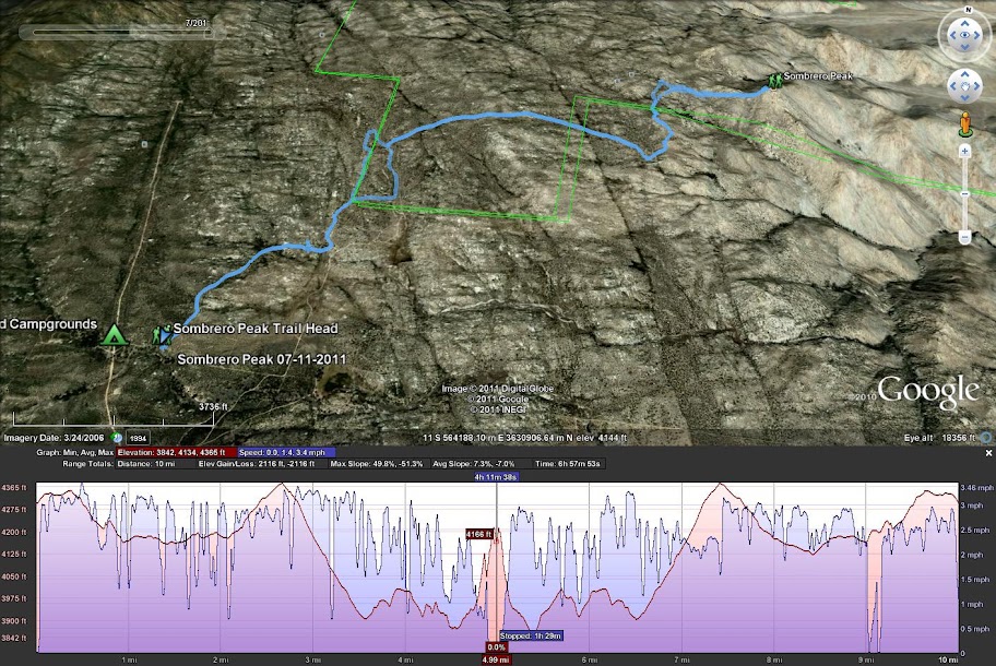
Here is my hike from last year, I missed a turn or two also....

--
http://www.sefcik.com
http://www.darensefcik.com
http://www.carrizogorge.com
|
|
|
link
|
|
anutami Posts: 491
11/28/2012
|
Missing a turn or two is not that bad as long as you peak in the small caves and you might find interesting things...
|
|
|
link
|
|
AdventureGraham Posts: 170
11/29/2012
|
ziphius wrote:
John,
That is a nice route to Sombrero. There is a great (I hope it is still there) gnarled, bonsai-like specimen of mountain mahogany growing out of a crack in a boulder almost at the summit. It's my favorite individual plant in the whole of ABDSP. Please pay my respects to it if you see it. It is likely over 100 years old. - Jim

edited by ziphius on 11/27/2012
I'll keep an eye out for it and get some photos if I can,
|
|
|
link
|
|
anutami Posts: 491
12/4/2012
|
surfponto wrote:
I would like to join but we may be doing a MTB ride out to Goat Canyon.
Bob, did you mtb ride the route? I was thinking about doing this soon as well. Do you just park at the gas station?
|
|
|
link
|
|
dsefcik Administrator Posts: 2634
12/4/2012
|
Nolan wrote:
Bob, did you mtb ride the route? I was thinking about doing this soon as well. Do you just park at the gas station?
I have always parked under the freeway near De Anza.
--
http://www.sefcik.com
http://www.darensefcik.com
http://www.carrizogorge.com
|
|
|
link
|
|
anutami Posts: 491
12/4/2012
|
Daren Sefcik wrote:
Nolan wrote:
Bob, did you mtb ride the route? I was thinking about doing this soon as well. Do you just park at the gas station?
I have always parked under the freeway near De Anza.
Here?

edited by anutami on 12/4/2012
|
|
|
link
|
|
dsefcik Administrator Posts: 2634
12/4/2012
|
yep, nice little shady spot on the north side overpass...but the gas station may be a safer location for your vehicle, you need to decide if the extra miles are worth it to you.
--
http://www.sefcik.com
http://www.darensefcik.com
http://www.carrizogorge.com
|
|
|
link
|
|
surfponto Administrator Posts: 1369
12/4/2012
|
No we didn't make it out last weekend
I am hoping this weekend
Nolan wrote:
surfponto wrote:
I would like to join but we may be doing a MTB ride out to Goat Canyon.
Bob, did you mtb ride the route? I was thinking about doing this soon as well. Do you just park at the gas station?
--
https://www.anzaborrego.net/


|
|
|
link
|