|
dsefcik Administrator Posts: 2634
2/6/2011
|
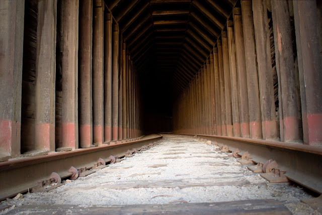
Wow! This was probably the most pristine and beautiful canyon/wash area I have ever hiked in the ABDSP area. When I first turned off the jeep trail and started hiking down the canyon I was memorized. I felt as if I was the only human to have ever walked thru it. I felt guilty of polluting it with my foot steps. Many, many animal tracks could be seen. Rabbit, Bighorn Sheep, Coyote, Mountain Lion, etc all were there. The 2.5 miles of canyon consisted of section after section of flat sandy wash with a dry fall at the end. Towards the middle of the canyon it was becoming too difficult to navigate with my big camera in my hands and I decided to put it in my backpack. No sooner did I click the waist buckle closed did I hear a sound up to my left. I looked up and less than '50 away was a Bighorn Ram staring straight at me. I knew if I moved he would run. He was big and had some major damage to his right leg area. I could see a lot of the fur was gone and there was a long black section of maybe scar or scab healing. After maybe 2-3 seconds of staring he bolted..gone up the rocky ridge, I never saw him or any other Bighorn that day. Eventually I got to the end of the canyon and to my surprise was an old train section consisting of three passenger cars and one caboose. The caboose was from Mexico and the passenger cars were form Montreal. The pastel greens inside the passenger cars were pretty funky and the brilliant,flashy colors of the Mexican caboose brought memorable images of past Mexico trips to my mind. After finally reaching the tracks and seeing the old railway pieces down in the gorge I realized I was almost out of time and needed to head back. I fast tracked down the gorge, fought the catclaw, took some pictures and headed back. I made good time going back and was able to get on the freeway by 5pm.
Please see the full trip report on my website http://www.sefcik.com/2011/02/carrizo-gorge-old-railway-train-parts.html


--
<em>edited by dsefcik on 2/6/2011</em>
--
http://www.sefcik.com
http://www.darensefcik.com
http://www.carrizogorge.com
|
|
|
link
|
|
surfponto Administrator Posts: 1369
2/7/2011
|
Still tripping on that train.
What is the story with that?
--
https://www.anzaborrego.net/


|
|
|
link
|
|
hikerdmb Posts: 423
2/7/2011
|
Daren,
That does look like a great area. Can you send me your GPS track so I can see where you started? Looks like it was a perfect day too.
David
|
|
|
link
|
|
surfponto Administrator Posts: 1369
2/8/2011
|
Hey Daren
Not to be a downer but I wonder if this is the area where the Sunrise Powerlink would pass through. 
It shows on the map that it will cut through Carrizo Gorge outside of the ABDSP border, although it may parallel closer to the 8 freeway
Did you also notice off to your left when you were driving home that they are clearing land in McCain Valley?
Looks like it was for a tower.
Bob
<em>edited by surfponto on 2/8/2011</em>
--
https://www.anzaborrego.net/


|
|
|
link
|
|
dsefcik Administrator Posts: 2634
2/8/2011
|
Not only were they clearing land north of the freeway in McCain Valley they were also clearing land near the Jacumba off ramp. Both sites had large boom type vehicles onsite. There were also numerous signs near Alpine about SDGE doing construction. These were clearly areas designated on the SDG&E SPL map.
Fortunately though the map bypasses the area I describe in this post 8
ughhh...
http://www.sdge.com/sunrisepowerlink/construction_updates.html
--
http://www.sefcik.com
http://www.darensefcik.com
http://www.carrizogorge.com
|
|
|
link
|
|
harmono Posts: 71
1/7/2013
|
hikerdmb wrote:
Daren,
That does look like a great area. Can you send me your GPS track so I can see where you started? Looks like it was a perfect day too.
David
I would be interested too. From what I gather it looks like you started near Jacumba, took a Jeep trail east to a canyon, then went down the canyon toward Carrizo Gorge to the tracks with Mt Tule in the distance. That would only be about 3-4 miles down the track from Jacumba I think.
--

IMG_1032 by harmono619, on Flickr
|
|
|
link
|
|
surfponto Administrator Posts: 1369
1/12/2013
|
I would like to hike in from that side also.
Let me know when you have tentative plans
dsefcik wrote:
Here is a Google Earth KML file of the trip. Great area, I want to go back and explore some more.
--
https://www.anzaborrego.net/


|
|
|
link
|
|
dsefcik Administrator Posts: 2634
1/12/2013
|
Here is a Google Earth KML file of the trip. Great area, I want to go back and explore some more.
edited by dsefcik on 1/13/2013
--
http://www.sefcik.com
http://www.darensefcik.com
http://www.carrizogorge.com
|
|
|
link
|
|
tommy750 Posts: 1071
1/15/2013
|
Nice trip! Your post got me to thinking and I ended up getting this. Wonder what it would capture if left in the same canyon for a night or two. Can't wait to try it out although it will be in the back yard. Any one have any experience with motion-activated trail cameras? Tom

51X9Zx089iL._AA300_ by tomteske, on Flickr
|
|
|
link
|
|
dsefcik Administrator Posts: 2634
1/15/2013
|
tommy750 wrote:
Any one have any experience with motion-activated trail cameras? Tom They are actually in many places you may not expect. ABDSP has them mounted in strategic places and so does Cuyamaca....you should be mindful of what you do out there, you may be on hidden camera...!!
Well, actually they are not hidden but you may not see them....
--
http://www.sefcik.com
http://www.darensefcik.com
http://www.carrizogorge.com
|
|
|
link
|